Share Rethinking I-94 — Minneapolis to St. Paul on FacebookShare Rethinking I-94 — Minneapolis to St. Paul on X (formerly Twitter)Share Rethinking I-94 — Minneapolis to St. Paul on LinkedinEmail Rethinking I-94 — Minneapolis to St. Paul link
Rethinking I-94 is a long-term effort to engage communities that live, work, commute and play along the corridor to promote effective movement of people and goods and a high quality of life for neighboring communities. In addition to enhancing mobility, safety, and connectivity, MnDOT is responsible for preserving and repairing bridges, walls, and pavement.
Rethinking I-94 improvements will support the broader community goals established for the project. Those goals include:
Incorporating MnDOT's livability framework and identifying opportunities for establishing a sense of place, community connections, economic opportunities, equity, safety, and a healthy environment for the communities that live, work, and play there.
Developing and executing a community-based approach focused on reconnecting neighborhoods, revitalizing communities, and ensuring residents have a meaningful voice in transportation decisions that affect their lives.
We recognize the actions 60 years ago devastated communities, and those impacts are still felt today. This is the first comprehensive review of I-94 since its construction in the 1960s and is jointly conducted by MnDOT and the Federal Highway Administration (FHWA).
Get involved
Interested in getting involved or providing feedback?
Rethinking I-94 is a long-term effort to engage communities that live, work, commute and play along the corridor to promote effective movement of people and goods and a high quality of life for neighboring communities. In addition to enhancing mobility, safety, and connectivity, MnDOT is responsible for preserving and repairing bridges, walls, and pavement.
Rethinking I-94 improvements will support the broader community goals established for the project. Those goals include:
Incorporating MnDOT's livability framework and identifying opportunities for establishing a sense of place, community connections, economic opportunities, equity, safety, and a healthy environment for the communities that live, work, and play there.
Developing and executing a community-based approach focused on reconnecting neighborhoods, revitalizing communities, and ensuring residents have a meaningful voice in transportation decisions that affect their lives.
We recognize the actions 60 years ago devastated communities, and those impacts are still felt today. This is the first comprehensive review of I-94 since its construction in the 1960s and is jointly conducted by MnDOT and the Federal Highway Administration (FHWA).
Get involved
Interested in getting involved or providing feedback?
Share Project update on FacebookShare Project update on X (formerly Twitter)Share Project update on LinkedinEmail Project update link
We are in the process of reviewing and preparing responses to all comments that were submitted on the Scoping Document / Draft Scoping Decision Document (SD/DSDD) and the state Environmental Assessment Worksheet (EAW) during the public comment period. We expect to post the final Scoping Decision Document and Findings of Fact and Conclusions (FOFC) document for the EAW, including responses to comments received, on the project website later in 2026.
In September 2025, the Federal Highway Administration (FHWA) received feedback and concurrence (support) from Cooperating Agencies on the Alternatives Evaluation Memo. Cooperating Agencies are federal agencies that assist with theContinue reading
We are in the process of reviewing and preparing responses to all comments that were submitted on the Scoping Document / Draft Scoping Decision Document (SD/DSDD) and the state Environmental Assessment Worksheet (EAW) during the public comment period. We expect to post the final Scoping Decision Document and Findings of Fact and Conclusions (FOFC) document for the EAW, including responses to comments received, on the project website later in 2026.
In September 2025, the Federal Highway Administration (FHWA) received feedback and concurrence (support) from Cooperating Agencies on the Alternatives Evaluation Memo. Cooperating Agencies are federal agencies that assist with the environmental review process. The memo was also shared with Participating Agencies — other federal, state, and local agencies with an interest in the project — for their information.
The Alternatives Evaluation Memo identifies recommended alternatives to move forward for further study in the next phase of the project, the Tier 1 Environmental Impact Statement (EIS). Alternatives recommended to advance include: No Build, Maintenance B, Reduced Freeway and Reconfigured Freeway.
MnDOT prepared a draft of the SD/DSDD and shared it with Cooperating and Participating agencies for review and comment. An Environmental Assessment Worksheet (EAW) was prepared and shared with Participating agencies for comment. MnDOT incorporated their comments into the documents and provided an update on these documents to Community Leaders and the Policy Advisory Committee.
The SD/DSDD and EAW were released for official public comment from January 6 – March 23, 2026. MnDOT hosted official public meetings (in-person and virtual) to collect comments on the documents.
To learn more about the alternatives, the evaluation of alternatives, and recommendations for further study in the Tier 1 EIS, visit the project StoryMap.
Share Public engagement updates on FacebookShare Public engagement updates on X (formerly Twitter)Share Public engagement updates on LinkedinEmail Public engagement updates link
Phase 1 (2016-2018)
Prior to the start of the federal and state environmental processes, we engaged with communities along I-94 and listened to what people had to say about their transportation needs and desires.
We heard from the community members that there is interest in transportation and making improvements to I-94. We also heard that community members had interests and desires beyond transportation that should be considered by MnDOT and others when making road improvements.
Prior to the start of the federal and state environmental processes, we engaged with communities along I-94 and listened to what people had to say about their transportation needs and desires.
We heard from the community members that there is interest in transportation and making improvements to I-94. We also heard that community members had interests and desires beyond transportation that should be considered by MnDOT and others when making road improvements.
Share Meetings and events on FacebookShare Meetings and events on X (formerly Twitter)Share Meetings and events on LinkedinEmail Meetings and events link
Upcoming
Information about upcoming meetings and events will be provided as details become available.
Past
Feb. 19, 2026: In-person public meeting, Wilder Foundation, St. Paul
Meeting information: same information used for the Jan. 29 and Feb. 4 meetings
MnDOT invites and encourages participation by all people in their programs, services and activities. If you need an ASL, a foreign language interpreter, or documents in an alternative format (such as braille, largeContinue reading
Upcoming
Information about upcoming meetings and events will be provided as details become available.
Past
Feb. 19, 2026: In-person public meeting, Wilder Foundation, St. Paul
Meeting information: same information used for the Jan. 29 and Feb. 4 meetings
MnDOT invites and encourages participation by all people in their programs, services and activities. If you need an ASL, a foreign language interpreter, or documents in an alternative format (such as braille, large print or in a different language) at no cost, please email your request to Janet Miller at ADArequest.dot@state.mn.us(External link) or call 651-366-4720. Relay service: 711.
If you need any other reasonable accommodation to participate (such as seating modification or auxiliary aids), please email your request to Accessibility.DOT@state.mn.us(External link) or call 1-833-400-8432. Relay service: 711.
Share Alternatives on FacebookShare Alternatives on X (formerly Twitter)Share Alternatives on LinkedinEmail Alternatives link
Overview
MnDOT is currently working with local and federal agency partners and working groups to evaluate the alternatives. MnDOT anticipates completing the alternatives evaluation and sharing these results with the public in late fall 2025. To learn more about the recommendations, please visit the Story Map. Select the “Evaluation and Recommendations” tab on the top of the page and scroll down to “Alternatives Moving Forward/Alternatives Not Moving Forward.”
The Scoping Document/Draft Scoping Decision Document (SD/DSDD) will be released in late fall 2025/early winter 2026. This document is used to identify key issues and concerns needing more study in theContinue reading
Overview
MnDOT is currently working with local and federal agency partners and working groups to evaluate the alternatives. MnDOT anticipates completing the alternatives evaluation and sharing these results with the public in late fall 2025. To learn more about the recommendations, please visit the Story Map. Select the “Evaluation and Recommendations” tab on the top of the page and scroll down to “Alternatives Moving Forward/Alternatives Not Moving Forward.”
The Scoping Document/Draft Scoping Decision Document (SD/DSDD) will be released in late fall 2025/early winter 2026. This document is used to identify key issues and concerns needing more study in the Tier 1 Environmental Impact Statement (EIS). It also officially identifies the alternatives recommended to move forward for study in the Tier 1 EIS. A formal public comment period will be scheduled late fall 2025/early winter 2026. MnDOT will collect comments and respond to them in the Scoping Decision Document (SDD) which will finalize the alternatives to be studied in the Tier 1 EIS and the areas of focus for additional study.
The alternatives were released in July 2023. The 10 alternatives combine highway and transit ideas, and included details like the roadway type, number of travel lanes, transit services and potential transit stop locations. Alternatives moving forward into the Tier 1 EIS will be further developed and refined based on feedback and additional technical review.
Details such as overpasses, intersections, ramps, frontage roads, parking, landscaping, corridor enhancements and transit stops will be studied in more detail in the Tier 1 EIS. Below are the alternatives released in July 2023.
Public engagement
From June to November of 2023, MnDOT hosted in-person and virtual public meetings, conducted an online survey, met with partners, community-based organizations and other key stakeholders, and attended multiple community events to collect public feedback on the alternatives. The feedback received will be used to refine and further develop alternatives. You can review a summary of the public engagement efforts that took place following the release of the alternatives.
A formal public comment period on the SD/DSDD is expected to be scheduled for late fall 2025/winter 2026. There will be several ways to comment on the SD/DSDD.
Alternatives survey responder demographics
An online survey about the alternatives was open from July - October 2023. The survey was designed for people to provide open-ended feedback on the 10 alternatives MnDOT presented in July. This summary presents the survey results broken down by demographics for further insights. People could complete the survey without providing their demographic information. As a result, there are inconsistencies in the number of responders across the various questions and categories.
In 2024 and 2025, MnDOT continued to meet with community members, interest groups, elected officials and cooperating agencies to share information and listen to feedback on the alternatives to inform their evaluation.
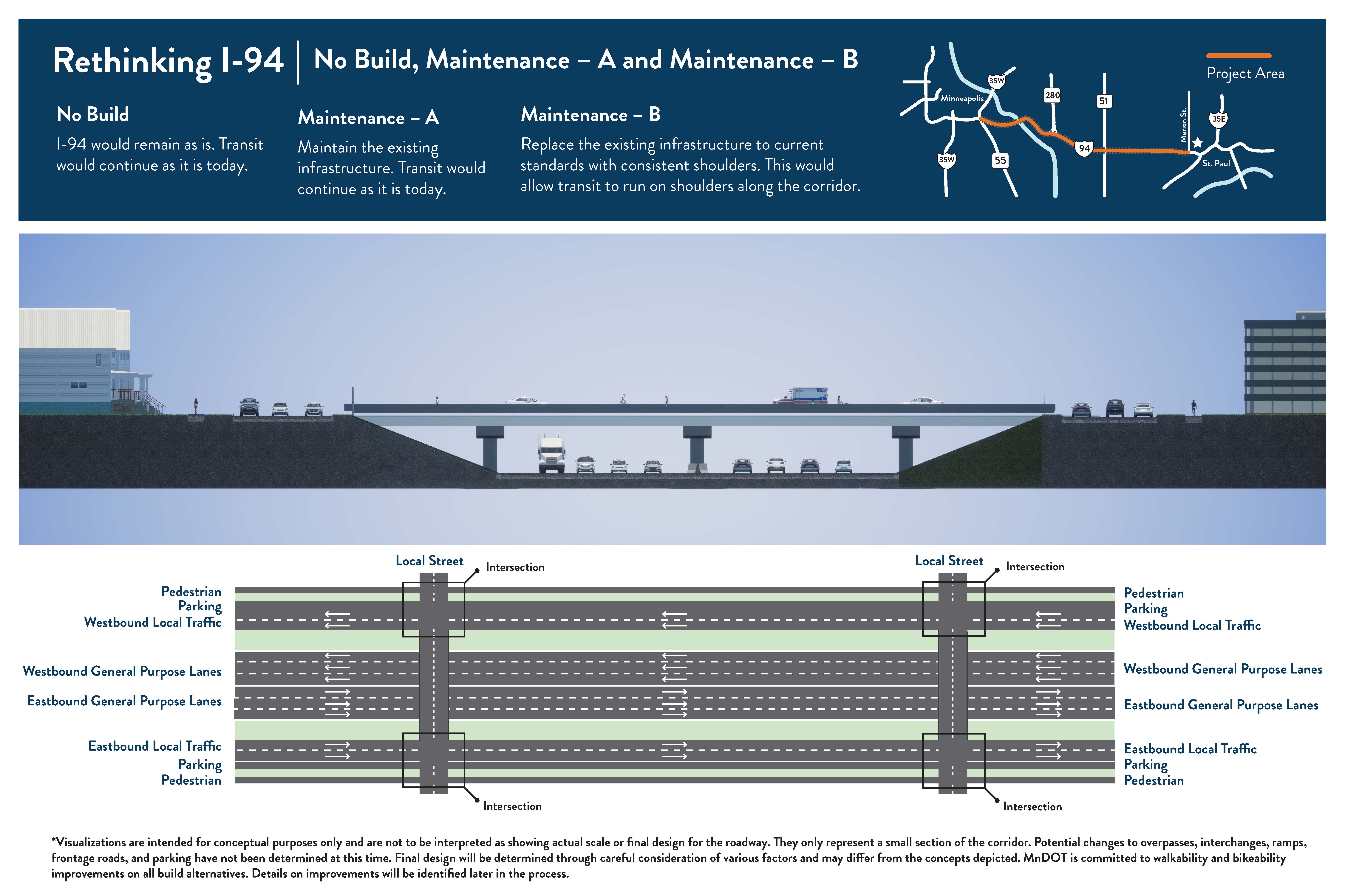
No Build, Maintenance – A, and Maintenance – B
No Build: I-94 would remain as is. Existing transit service would continue.
Maintenance – A: Maintain the existing infrastructure. Existing transit service would continue.
Maintenance– B: Replace the existing infrastructure to current standards with consistent shoulders. This would allow transit to run on bus shoulders between downtown Minneapolis and downtown St. Paul.
Roadway type: Keeps a freeway with the same number of travel lanes.
Number of travel lanes: No changes from existing. Varies between three and four lanes in both directions.
Transit: No change from current service (Route 94 express bus). Maintenance B would extend bus shoulders to match conditions prior to I-35W bridge collapse.
Access changes: No changes from existing.
Pedestrian and bicycle: No major changes from existing. All crossings of I-94 would be a bridge – either pedestrian/bicycle-only or a roadway with pedestrian and/or bicycle facilities (such as a trail, sidewalk, or bike lanes). With Maintenance B, some new/improved facilities could be provided if bridges are replaced.
No Build, Maintenance –A
The freeway would not be reconstructed. Maintenance A would allow for more in-depth maintenance activities.
The overall number of lanes would not change. Currently the number of general purpose lanes varies between 3 and 4 in both directions.
Existing express bus transit service (Metro Transit Route 94) would continue.
No changes to pedestrian or bicycle facilities.
No changes to interchanges or ramps along the freeway.
Maintenance –B
The freeway would be reconstructed with the same number of lanes.
Existing express bus transit service (Metro Transit Route 94) would continue. Current bus shoulders would be extended to connect downtown Minneapolis and downtown St. Paul.
Some new/improved pedestrian or bicycle facilities could be provided if bridges are replaced.
No changes to interchanges or ramps along the freeway.
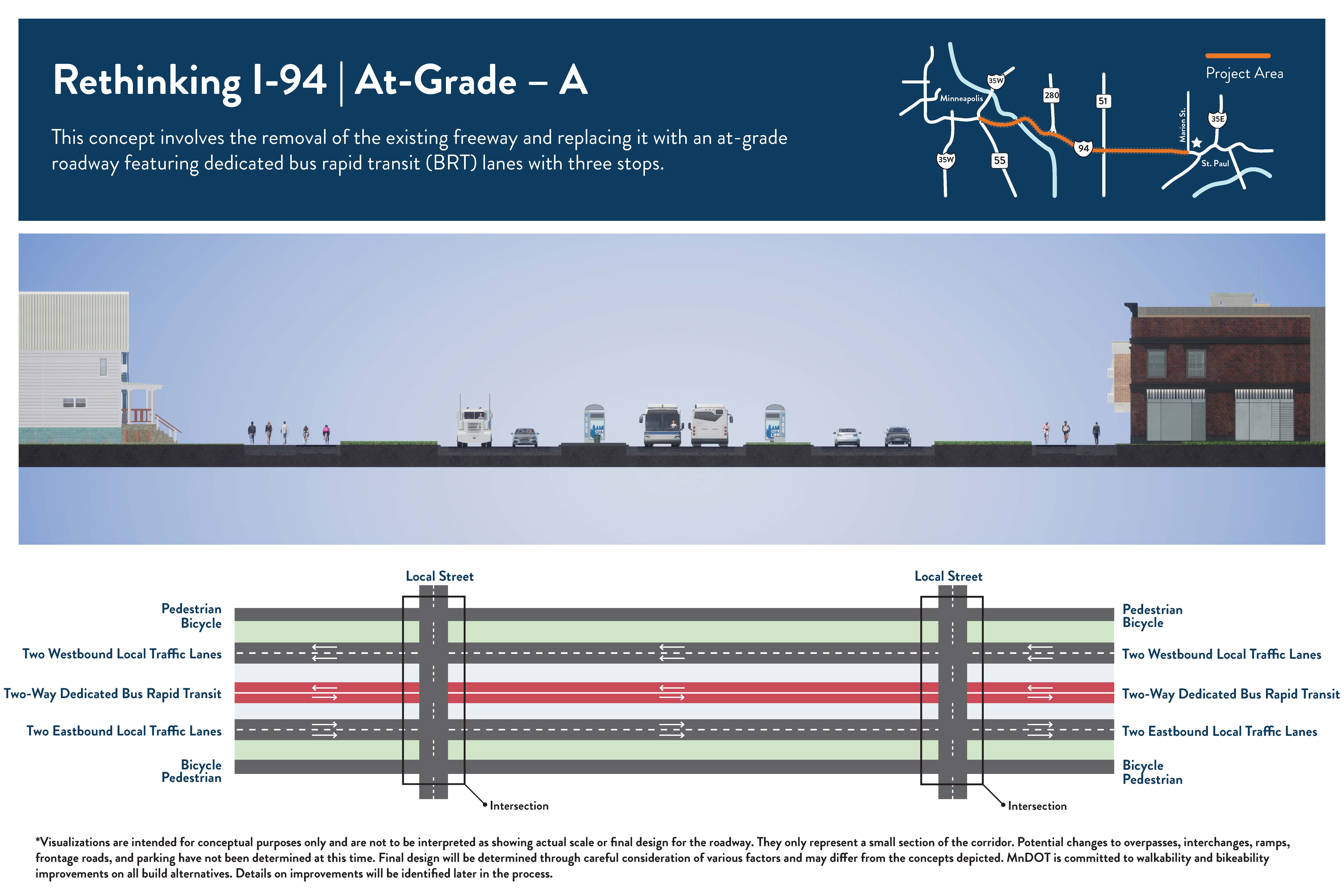
At-Grade – A
This concept involves the removal of the existing freeway, filling in the corridor, and constructing a new at-grade roadway. It also features dedicated bus rapid transit (BRT) lanes in the center with up to three stops.
Roadway type: Removes the freeway (and Interstate designation within project area). Constructs at-grade roadway in same location.
Number of travel lanes: 2 lanes in each direction for all vehicles and 1 dedicated bus rapid transit (BRT) lane in each direction in the center of the roadway.
Transit: BRT in dedicated lanes in the center of the roadway with up to 3 stops (Locations to be determined).
Access changes: Current interchanges, on/off ramp locations, and other bridges and underpasses would be converted to intersections with the new roadway (intersection designs to be determined). Some bridges for cross traffic may remain due to the elevations of existing roadways. Frontage roads/side streets may be modified or removed.
Pedestrian and bicycle: Most crossings would be “at-grade” (people would use crosswalks to get across the lanes of traffic) because current bridges and underpasses would be converted to intersections. Pedestrian/bicycle bridges over the road may be possible in some areas. There is potential to include pedestrian and/or bicycle facilities (such as a trail, sidewalk, or bike lanes) along the north and/or south sides of the new roadway. Specific changes are to be determined.
The freeway would be removed and replaced with a road that would have 2 lanes for all vehicles and 1 dedicated transit lane (for buses only) in both directions.
The overall number of lanes is reduced. Currently the number of general purpose lanes varies between 3 and 4 in both directions.
Transit will operate in the dedicated lanes in the center of the roadway with up to 3 stops.
There would likely be a mix of at-grade pedestrian and bicycle crossings (people would use crosswalks to get across the lanes of traffic) and pedestrian/bicycle bridges depending on the location.
New pedestrian and/or bicycle facilities are possible.
Current interchanges and most crossing locations would be converted to intersections.
In some locations a bridge for railroad crossings, pedestrian and bicycle facilities, or local roadways may remain due to the terrain.
Current frontage roads/side streets may be removed or incorporated into the at-grade design.
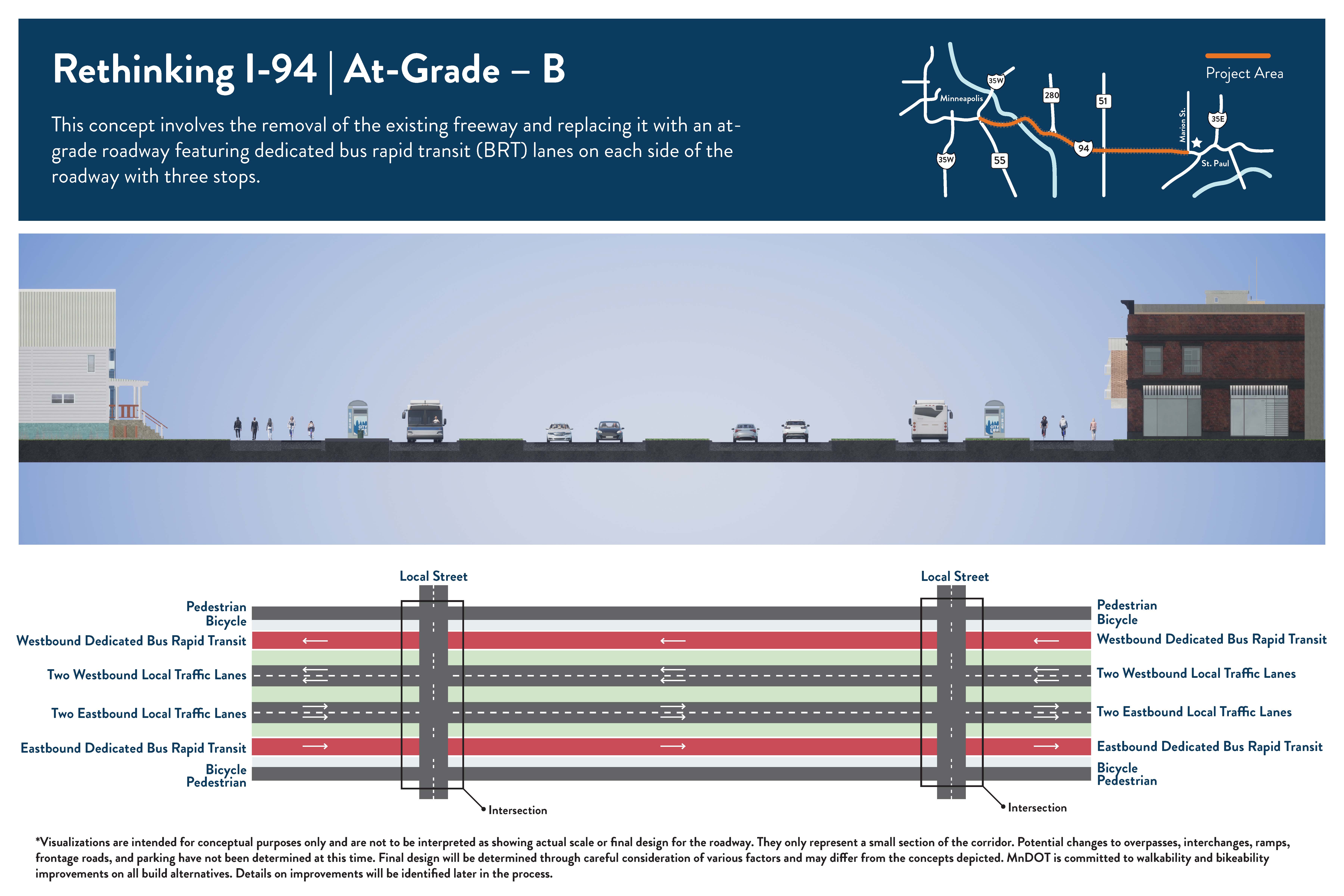
At-Grade – B
This concept involves the removal of the existing freeway, filling in the corridor, and constructing a new at-grade roadway. It also features dedicated bus rapid transit (BRT) lanes on the outside of the roadway with up to three stops.
Roadway type: Removes the freeway (and Interstate designation within project area). Constructs at-grade roadway in same location.
Number of travel lanes:2 lanes in each direction for all vehicles and 1 dedicated bus rapid transit (BRT) lane in each direction on the outside of the roadway.
Transit:BRT in dedicated lanes on the outside of the roadway with up to 3 stops (Locations to be determined).
Access changes: Current interchanges, on/off ramp locations, and other bridges and underpasses would be converted to intersections with the new roadway (intersection designs to be determined). Some bridges for cross traffic may remain due to the elevations of existing roadways. Frontage roads/side streets may be modified or removed.
Pedestrian and bicycle:Most crossings would be “at-grade” (people would use crosswalks to get across the lanes of traffic) because current bridges and underpasses would be converted to intersections. Pedestrian/bicycle bridges over the road may be possible in some areas. There is potential to include pedestrian and/or bicycle facilities (such as a trail, sidewalk, or bike lanes) along the north and/or south sides of the new roadway. Specific changes are to be determined.
The freeway would be removed and replaced with a road that would have 2 lanes for all vehicles and 1 dedicated transit lane (for buses only) in both directions.
The overall number of lanes is reduced. Currently the number of general purpose lanes varies between 3 and 4 in both directions.
Transit will operate in the dedicated lanes on the outside of the roadway with up to 3 stops.
There would likely be a mix of at-grade pedestrian and bicycle crossings (people would use crosswalks to get across the lanes of traffic) and pedestrian/bicycle bridges depending on the location.
New pedestrian and/or bicycle facilities are possible.
Current interchanges and most crossing locations would be converted to intersections.
In some locations a bridge for railroad crossings, pedestrian and bicycle facilities, or local roadways may remain due to the terrain.
Current frontage roads/side streets may be removed or incorporated into the at-grade design.
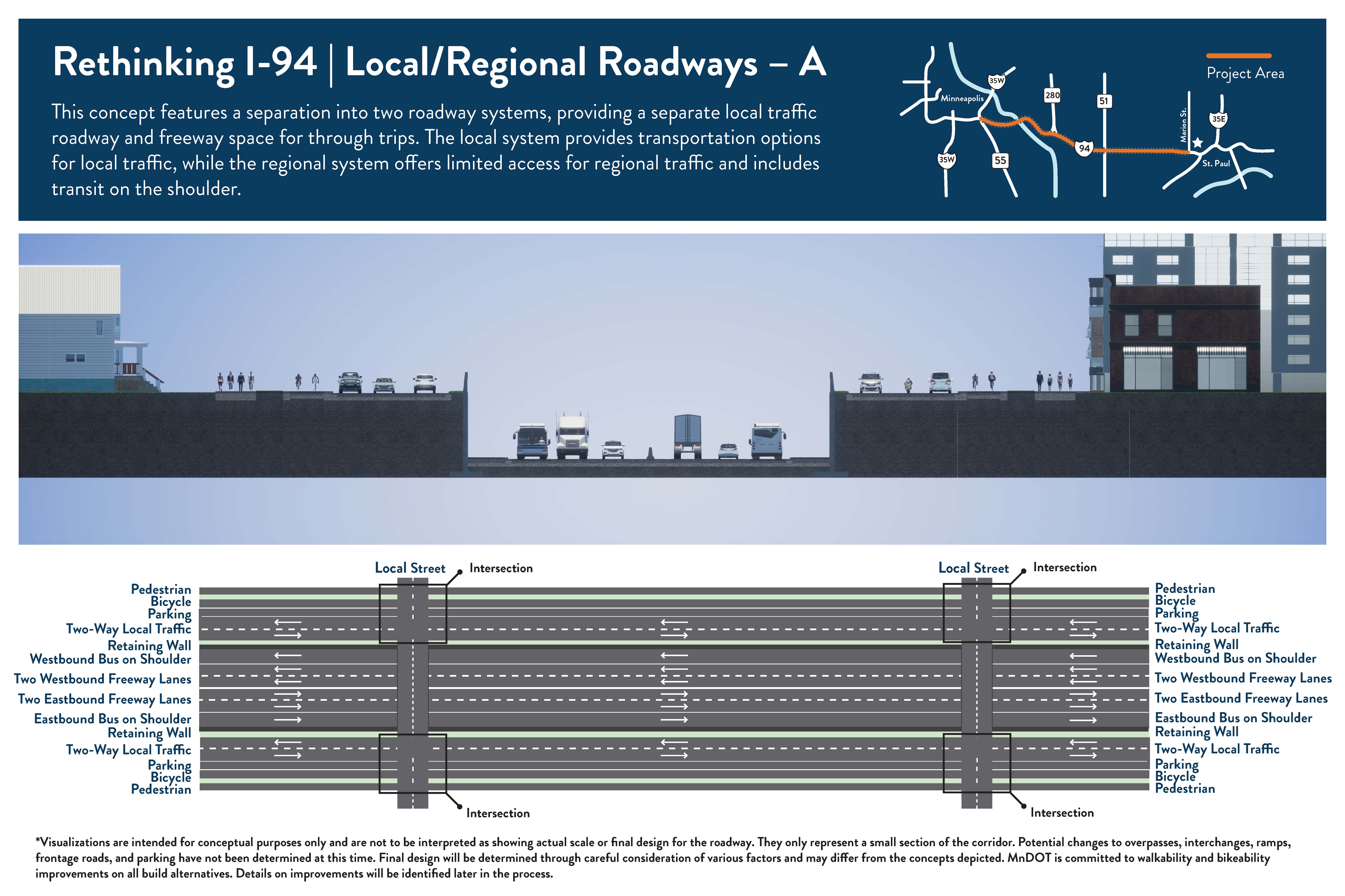
Local/Regional Roadways – A
This concept features a separation into two roadway systems, providing a local traffic roadway and freeway space for through trips. The local system provides transportation options for local traffic, while the regional system offers limited access for regional traffic and includes transit on the shoulder.
Roadway type: Keeps a reduced size freeway. Constructs local roadways on both sides.
Number of travel lanes:Freeway: 2 lanes in each direction for all vehicles and a shoulder that buses can use in each direction. Local Roadways: 1 lane in each direction for all vehicles (on both sides of freeway).
Transit:Transit on shoulders on the freeway (Stop locations to be determined). Local bus route changes to be determined.
Access changes:Access changes to be determined. Interchanges will be limited and some will be removed. Potential to modify interchanges in some locations including on/off ramp changes or removal. Potential changes to frontage roads/side streets may occur in some locations.
Pedestrian and bicycle:To be determined. All crossings of I-94 would be a bridge – either pedestrian/bicycle-only or a roadway with pedestrian and/or bicycle facilities (such as a trail, sidewalk, or bike lanes). Potential to include pedestrian and/or bicycle facilities on roads that go east-west (like I-94) to the north or south of I-94 since bicyclists and pedestrians are not allowed on Interstate routes.
The freeway would be reconstructed and narrowed to have 2 general purpose lanes (all vehicles can use) and a bus shoulder in both directions.
Two-way local streets will be constructed on each side of the freeway, with speed limits expected to be lower than the freeway.
Current frontage roads/side streets may be removed or incorporated into the local roadway design.
The overall number of freeway lanes is reduced throughout the project corridor. Currently the number of general purpose lanes varies between 3 and 4 in both directions.
Transit will operate on the shoulders on the regional system. Local bus route changes to be determined.
Current pedestrian facilities would be improved, and additional pedestrian and bicycle crossings will be considered.
New pedestrian and/or bicycle facilities along the new local roadways are possible.
Current interchanges along the freeway would be modified or removed to improve mobility and safety. Most existing on/off ramps along the freeway would be removed.
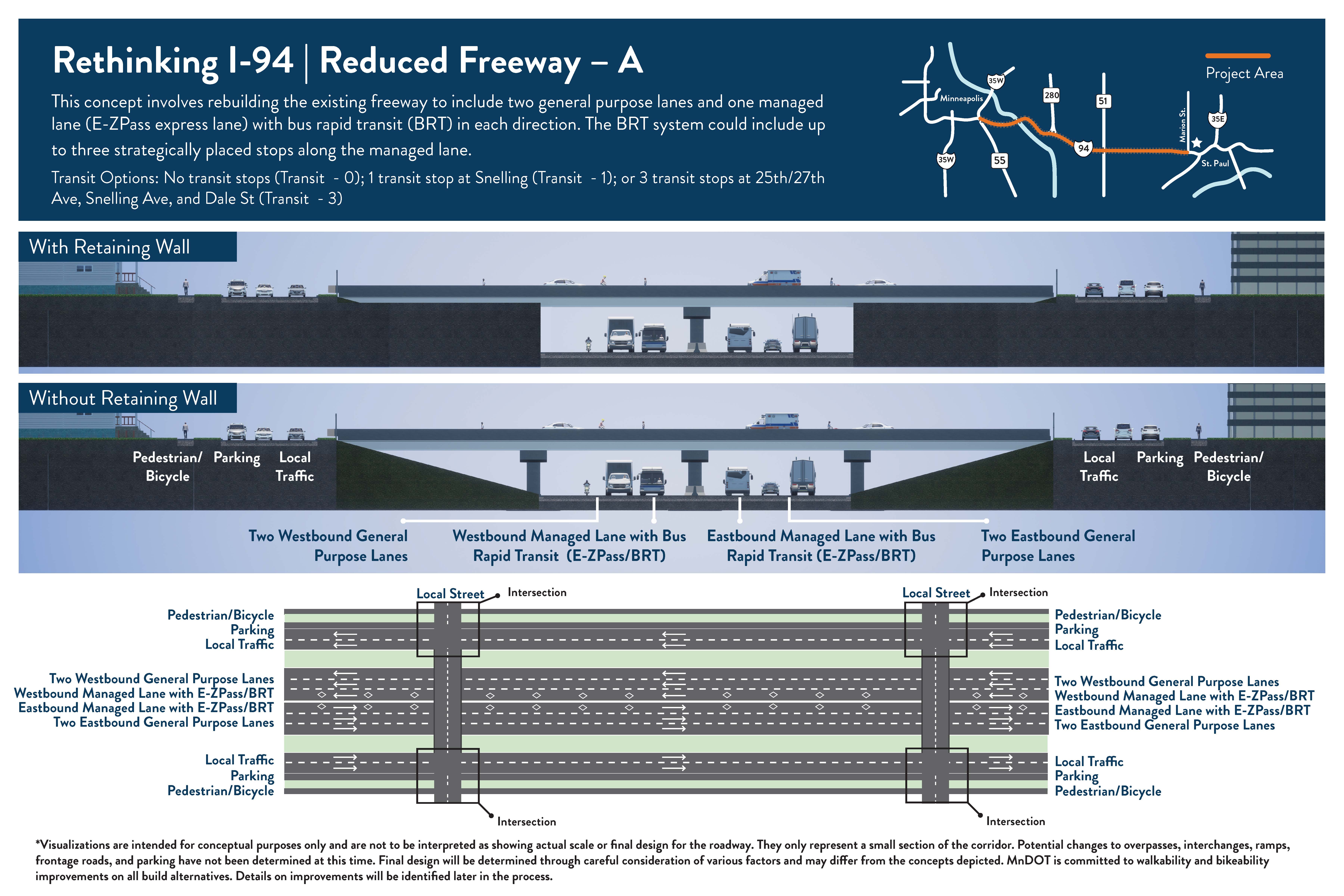
Reduced Freeway – A
This concept involves rebuilding the existing freeway to include 2 general purpose lanes and 1 managed lane with bus rapid transit (BRT) in each direction. The BRT system could include up to three stops.
Roadway type: Keeps a freeway. Reduces the number of travel lanes.
Number of travel lanes:2 lanes in each direction for all vehicles and 1 managed lane in each direction (for buses, people that carpool, and those willing to pay).
Transit:Bus rapid transit (BRT) in managed lanes with no stops; 1 stop at Snelling Ave; or 3 stops at 25th/27th Ave, Snelling Ave, and Dale St (Final locations to be determined).
Access changes:Access changes to be determined. Potential to modify interchanges in some locations including on/off ramp changes or removal. Potential changes to frontage roads/side streets may occur in some locations.
Pedestrian and bicycle:To be determined. All crossings of I-94 would be a bridge – either pedestrian/bicycle-only or a roadway with pedestrian and/or bicycle facilities (such as a trail, sidewalk, or bike lanes). Potential to include pedestrian and/or bicycle facilities on roads that go east-west (like I-94) to the north or south of I-94 (frontage roads) since bicyclists and pedestrians are not allowed on Interstate routes.
The freeway would be reconstructed to have 2 general purpose lanes (all vehicles can use) and 1 managed lane (for buses, those that carpool, and those willing to pay) in both directions. Outside of peak hours, managed lanes operate as general purpose lanes.
The overall number of lanes is reduced throughout the project corridor. Currently the number of general purpose lanes varies between 3 and 4 in both directions.
Transit will operate in the managed lanes.
Current pedestrian facilities would be improved, and additional pedestrian and bicycle crossings will be considered.
Interchanges and ramps along the freeway would be studied to improve mobility and safety.
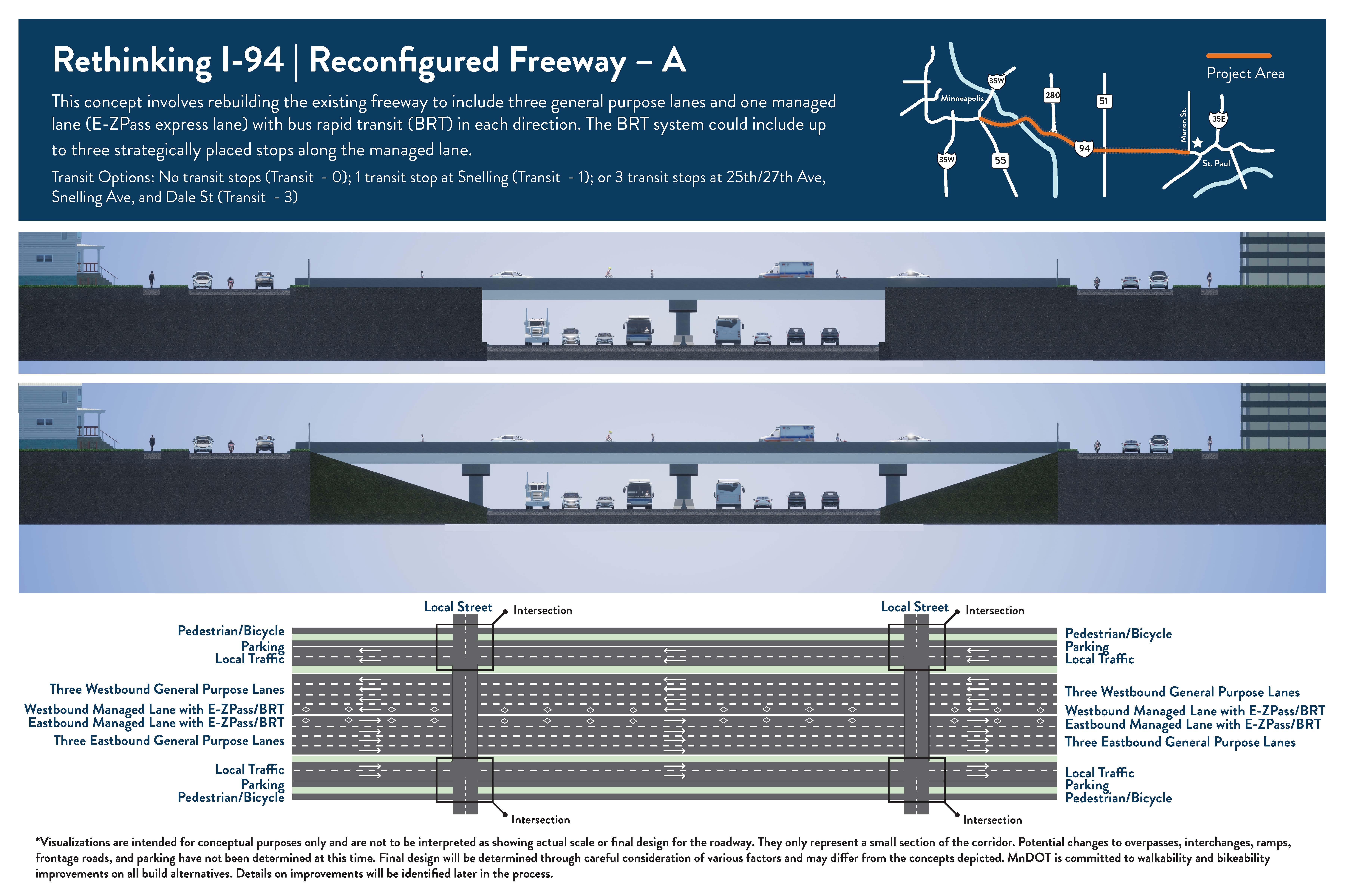
Reconfigured Freeway – A
This concept involves rebuilding the existing freeway to include 3 general purpose lanes and 1 managed lane with bus rapid transit (BRT) in each direction. The BRT system could include up to three stops along the managed lane.
Roadway type: Keeps a freeway. Changes the type of travel lanes available.
Number of travel lanes:3 lanes in each direction for all vehicles and 1 managed lane in each direction (for buses, people that carpool, and those willing to pay).
Transit:Bus rapid transit (BRT) in managed lanes with no stops; 1 stop at Snelling Ave; or 3 stops at 25th/27th Ave, Snelling Ave, and Dale St (Final locations to be determined).
Access changes:Access changes to be determined. Potential to modify interchanges in some locations including on/off ramp changes or removal. Potential changes to frontage roads/side streets may occur in some locations.
Pedestrian and bicycle:To be determined. All crossings of I-94 would be a bridge – either pedestrian/bicycle-only or a roadway with pedestrian and/or bicycle facilities (such as a trail, sidewalk, or bike lanes). Potential to include pedestrian and/or bicycle facilities on roads that go east-west (like I-94) to the north or south of I-94 (frontage roads) since bicyclists and pedestrians are not allowed on Interstate routes.
The freeway would be reconstructed to have 3 general purpose lanes (all vehicles can use) and 1 managed lane (for buses, those that carpool, and those willing to pay) in both directions. Outside of peak hours, managed lanes operate as general purpose lanes.
The overall number of lanes stays the same throughout the project corridor. Currently the number of general purpose lanes varies between 3 and 4 in both directions.
Transit will operate in the managed lanes.
Current pedestrian facilities would be improved, and additional pedestrian and bicycle crossings will be considered.
Interchanges and ramps along the freeway would be studied to improve mobility and safety.
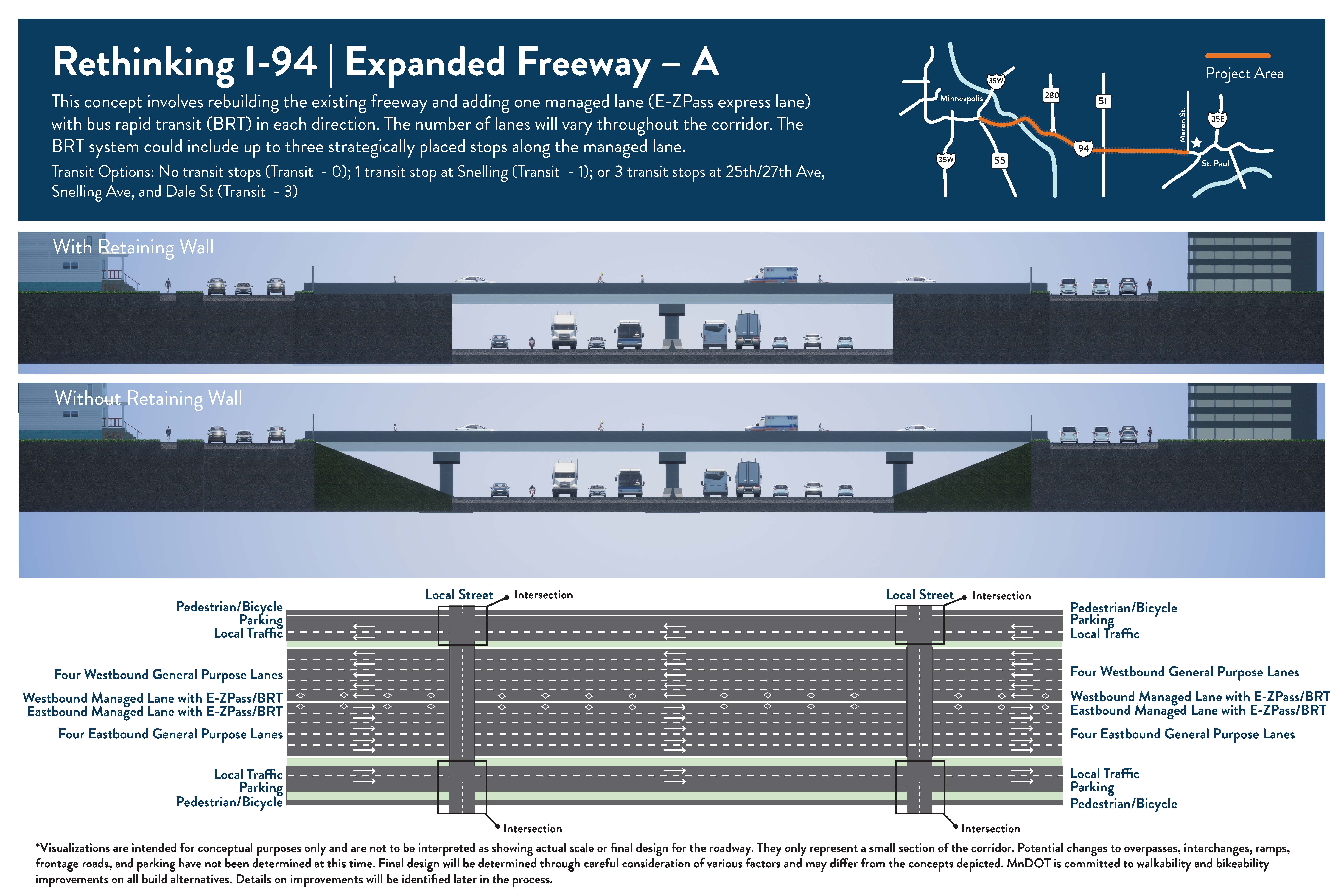
Expanded Freeway – A
This concept involves rebuilding the existing freeway and adding 1 managed lane with bus rapid transit (BRT) in each direction. The BRT system could include up to three stops. The total number of lanes will vary because the current number of lanes also varies.
Roadway type: Keeps a freeway. Adds a new managed lane.
Number of travel lanes:3-4 lanes in each direction for all vehicles and 1 managed lane in each direction (for buses, people that carpool, and those willing to pay).
Transit:Bus rapid transit (BRT) in managed lanes with no stops; 1 stop at Snelling Ave; or 3 stops at 25th/27th Ave, Snelling Ave, and Dale St (Final locations to be determined).
Access changes:Access changes to be determined. Potential to modify interchanges in some locations including on/off ramp changes or removal. Potential changes to frontage roads/side streets may occur in some locations.
Pedestrian and bicycle:To be determined. All crossings of I-94 would be a bridge – either pedestrian/bicycle-only or a roadway with pedestrian and/or bicycle facilities (such as a trail, sidewalk, or bike lanes). Potential to include pedestrian and/or bicycle facilities on roads that go east-west (like I-94) to the north or south of I-94 (frontage roads) since bicyclists and pedestrians are not allowed on Interstate routes.
The freeway would be reconstructed to have 3-4 general purpose lanes (all vehicles can use) and 1 managed lane (for buses, those that carpool, and those willing to pay) in both directions. The managed lane would be an addition to the current number of lanes. Outside of peak hours, managed lanes operate as general purpose lanes.
The overall number of lanes will increase by 1 throughout the project corridor. Currently the number of general purpose lanes varies between 3 and 4 in both directions.
Transit will operate in the managed lanes.
Current pedestrian facilities would be improved, and additional pedestrian and bicycle crossings will be considered.
Interchanges and ramps along the freeway would be studied to improve mobility and safety.
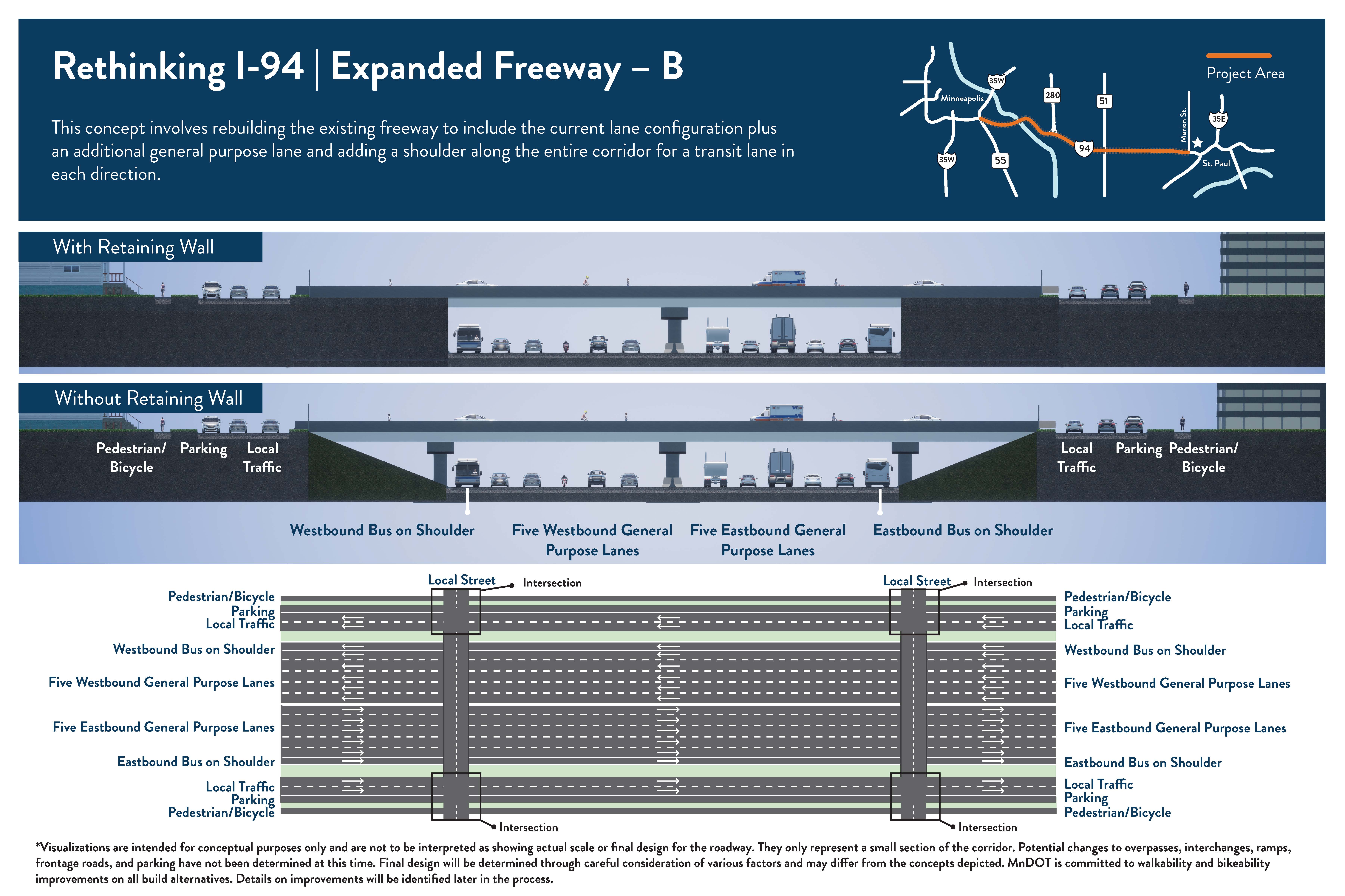
Expanded Freeway – B
This concept involves rebuilding the existing freeway and adding 1 new lane (for all vehicles) and extending the bus shoulder along the entire corridor in each direction. The total number of lanes will increase.
Roadway type: Keeps a freeway. Adds a new lane for all vehicles and extends bus shoulders.
Number of travel lanes:4-5 lanes in each direction for all vehicles.
Transit:Bus shoulders between downtown Minneapolis and downtown St. Paul with 1 stop at Snelling Ave.
Access changes:Access changes to be determined. Potential to modify interchanges in some locations including on/off ramp changes or removal. Potential changes to frontage roads/side streets may occur in some locations.
Pedestrian and bicycle:To be determined. All crossings of I-94 would be a bridge – either pedestrian/bicycle-only or a roadway with pedestrian and/or bicycle facilities (such as a trail, sidewalk, or bike lanes). Potential to include pedestrian and/or bicycle facilities on roads that go east-west (like I-94) to the north or south of I-94 (frontage roads) since bicyclists and pedestrians are not allowed on Interstate routes.
The freeway would be reconstructed to have 4-5 general purpose lanes (all vehicles can use) and a consistent shoulder in both directions.
The overall number of lanes will increase by 1 throughout the project corridor. Currently the number of general purpose lanes varies between 3 and 4 in both directions.
Transit will operate in shoulders. Current bus shoulders would be extended to connect downtown Minneapolis and downtown St. Paul.
Current pedestrian facilities would be improved, and additional pedestrian and bicycle crossings will be considered.
Interchanges and ramps along the freeway would be studied to improve mobility and safety.
Share Evaluation Process on FacebookShare Evaluation Process on X (formerly Twitter)Share Evaluation Process on LinkedinEmail Evaluation Process link
Rethinking I-94 Evaluation Criteria
Evaluation criteria have been developed for the Scoping Document (SD) and Tier 1 Environmental Impact Statement (EIS) phases of Rethinking I-94. This is the first step of the alternative evaluation process. The criteria used in the SD and Tier 1 EIS were developed concurrently for review and general agreement. Following Scoping , the Tier 1 EIS evaluation will be reassessed to refine criteria as needed.
Learn more about the evaluation criteria and how the alternatives were evaluated by watching the Evaluation Criteria video.
Groups and categories
There are four main groups of criteria with severalContinue reading
Rethinking I-94 Evaluation Criteria
Evaluation criteria have been developed for the Scoping Document (SD) and Tier 1 Environmental Impact Statement (EIS) phases of Rethinking I-94. This is the first step of the alternative evaluation process. The criteria used in the SD and Tier 1 EIS were developed concurrently for review and general agreement. Following Scoping , the Tier 1 EIS evaluation will be reassessed to refine criteria as needed.
Learn more about the evaluation criteria and how the alternatives were evaluated by watching the Evaluation Criteria video.
Groups and categories
There are four main groups of criteria with several categories under each. The four main groups and categories include:
Purpose and Need
Walkability and bikeabilty-comfort, mobility and risks for people walking, bicycling and rolling
Safety for people in motorized vehicles-cars freight, and transit
Infrastructure condition-state of repair
Mobility for people in motorized vehicles-cars, freight, and transit
Social, Economic, and Environmental (SEE)
Historic/archaeological/cemetery
Section 4(f) (recreational resources)
Section 6 (f) (recreational resources with special federal funding)
Contaminated properties
Right of way
Noise
Water pollution/stormwater
Air quality
Threatened & endangered species
Wetlands
Community goals
Sense of place
Access to transportation
Economic vitality
Quality of life
Connectivity
Additional Considerations
Cost
Maintenance
Consistency with adopted state and regional plans
Measures
For each subcategory, at least one criteria and measure have been identified to evaluate whether the alternative addresses the Purpose and Need, impacts/benefits SEE resources, is consistent with Community Goals and addresses additional considerations. Measurements include a mixture of quantitative and qualitative assessments. For measures with minimum standards, minimum performance criteria have been identified based on MnDOT or FHWA standards. Many of the standards and performance criteria have been documented in subject area technical memos.
Purpose and Need, SEE impacts or benefits and Community Goals will be evaluated by either comparing the alternative to the No Build or based on the subcategory’s performance measure. For example, Person Throughput (the number of people who pass a specific point in a defined timeframe) will be calculated for each alternative and documented as to whether it is higher, equal to, or lower than the No Build alternative.
Evaluation process
Alternatives will first be screened during the SDD Phase to determine whether they have “fatal flaws.” Alternatives with fatal flaws may not be technically or economically feasible, or they may result in SEE impacts that cannot be mitigated. For alternatives that do not have fatal flaws, the evaluation process will be first based upon the ability of an alternative to address the Purpose and Need criteria. Those that do not pass this screening will be eliminated as they are not “reasonable” alternatives. Alternatives that address the Purpose and Need will continue forward and will be further evaluated to understand the potential for and magnitude of impacts or benefits to SEE resources within the corridor. These impacts or benefits will be documented, and alternatives will then be evaluated to determine whether they address Community Goals along with several Additional Considerations.
Alternatives in the SDD Phase that best address the Purpose and Need evaluation criteria, minimize SEE impacts, and perform favorably in terms of Community Goals and Additional Considerations will move into the Tier 1 EIS. Tier 1 will use the identified criteria and measures to evaluate the remaining alternatives in greater detail. Because more design information will be available, additional measures for Purpose and Need, SEE impacts, Community Goals, and Additional Considerations will be incorporated to include items that were not expected to have substantial differences between alternatives in the SDD Phase. Evaluation in the Tier 1 EIS will first be based on addressing Purpose and Need criteria, followed by minimizing SEE impacts, and then meeting project goals and additional considerations. At the end of the Tier 1 process, an alternative that establishes the corridor footprint will be selected and a program of projects will be developed.
The following flow charts are of step 1 and 2 of this process.
Step 1: Scoping Decision Document (SDD) Phase
Step 2: Tier 1 EIS Phase
Topics not addressed in the Evaluation Criteria
Due to limitations in design detail and existing procedures, there are a variety of topics that are not part of the evaluation criteria or included at this phase of evaluation. In some cases, this is because the level of detail in the design at this stage prevents full investigation of the alternative. In other instances, certain interests are addressed by existing MnDOT standard procedures and will be implemented where feasible regardless of the selected alternative. More detailed aspects of design and evaluation will be addressed during project implementation in the Tier 2 process for Rethinking I-94.
Share Historical considerations on FacebookShare Historical considerations on X (formerly Twitter)Share Historical considerations on LinkedinEmail Historical considerations link
Community histories
A part of Rethinking I-94’s environmental review process is to evaluate the effects to historic properties. This evaluation is required by Section 106 of the National Historic Preservation Act. One of the first steps in the Section 106 process is to develop historic contexts for areas impacted by a project. More information on this process is available on our Cultural Resources Unit website.
Previously, most studies left gaps in the history of neighborhoods, trends, and groups in the area. Most existing historic contexts stop shortly after World War II and do not address the resource types andContinue reading
Community histories
A part of Rethinking I-94’s environmental review process is to evaluate the effects to historic properties. This evaluation is required by Section 106 of the National Historic Preservation Act. One of the first steps in the Section 106 process is to develop historic contexts for areas impacted by a project. More information on this process is available on our Cultural Resources Unit website.
Previously, most studies left gaps in the history of neighborhoods, trends, and groups in the area. Most existing historic contexts stop shortly after World War II and do not address the resource types and architectural styles developed from the post-war period to the present. Existing studies also focus primarily on white, Euro-American history with little to no mention of other racial, ethnic, and social communities. A priority of the Rethinking I-94 historic contexts is to address those gaps, creating a more inclusive understanding of the area’s history and what resources may be eligible for the National Register. The National Register of Historic Places is the official list of the Nation's historic places worthy of preservation. Authorized by the National Historic Preservation Act of 1966, the National Park Service's National Register of Historic Places is part of a national program to coordinate and support public and private efforts to identify, evaluate, and protect America's historic and archeological resources.
Report and summaries
We have written community histories that are more inclusive than past documentation. The community histories report is available for reading in individual chapters or short summaries. The contexts are separated into individual sections. Some are geographically based and discuss the historic development of specific neighborhoods. Others are thematic and cover a resource type or community history across the area.
MnDOT’s Cultural Resources Unit will be using the histories in future project review steps. We hope the community histories are also useful for the public, cities, counties, and others interested in better understanding the histories of the communities near I-94.
Some facts from the histories
The following items are just a few highlighted facts.
At the dawn of the automobile era, a heavily used street in Minneapolis and Saint Paul might be surfaced with brick, concrete, asphalt, or cobblestone, but side streets might not be paved. The rapid rise of the automobile – from approximately 55,000 nationwide in 1904 to one-half million in 1910—helped to catalyze county, state, and eventually federal efforts to create better roads. Read more in the Transportation chapter.
The Cedar Riverside neighborhood is historically one of the most diverse neighborhoods in the Twin Cities. Originally the port of entry for an influx of Scandinavian immigrants, the neighborhood has maintained its status as an immigrant hub since the late nineteenth century. Today is home to a sizeable Somali population. Read more in the Cedar Riverside chapter.
Union Park began not as a residential neighborhood but as an amusement park. In the early 1880s, businessmen Herman Grote and John O. Hinkel saw an opportunity to create a picturesque “pleasure resort” that “could be reached at any and all hours of the day, and which combined natural beauty and attractions with the conveniences of the city. The development had a 33-acre park with a dance pavilion, bandstand, and many attractions and events. At the height of its popularity, it boasted a one-day attendance of 10,000 visitors. Read more in the Union Park District chapter.
The American Indian Movement—a nationwide civil rights movement was founded in 1968 in Minneapolis, Minnesota. Read more in the American Indians in the Twin Cities chapter.
Approximately 433 houses were demolished and 300 businesses were closed or torn down in the Rondo neighborhood for the construction of I-94, and 72 percent of those were owned or occupied by Black people. Read more in the Rondo chapter.
The Minnesota Historical Society nominated Milwaukee Avenue to be included on the National Register of Historic Places for significance related to architecture and social history. On May 2, 1974, the street was officially designated as a place of national significance as the Milwaukee Avenue Historic District. Read more in the Seward chapter.
By 1882, Westminster Presbyterian Church in downtown Minneapolis was one of the largest Presbyterian churches in the United States at nearly two thousand members. Read more in the Places of Worship chapter.
During World War II, the Saint Anthony Park area was vital in manufacturing and shipping wartime products. As the war ended, construction boomed once more. Glendenning Motorways opened a new truck terminal at Pelham and Wabash Avenues. By 1951, the Midway Club estimated that more than fifty motor freight companies were in the district, as well as garages and service facilities to maintain the truck fleets. Read more in the St. Anthony Park chapter.
Most nineteenth-century development in the western part of the Study Area was single-family houses and or duplexes. Duplexes are widespread on the 1912 Sanborn maps. As the population of Minneapolis increased rapidly from the late nineteenth century onward, new higher-density apartment buildings helped meet demand. The apartment construction boom began around the turn of the century and continued until the start of the Great Depression. Prior to 1890, nearly 90 percent of Minneapolitans lived in single-family homes or duplexes; by 1930, the number of multi-family units had increased sevenfold, and more than 18 percent of the city’s residents lived in apartments. Read more in the Minneapolis Neighborhoods before the Interstate chapter.
The funeral industry was a path for Black entrepreneurs to own their own businesses and become community leaders during the late 1800s and early 1900s. Multiple Black-owned funeral homes in Minneapolis and Saint Paul were operated by married couples, making this field one of the few avenues for Black women to lead businesses. Read more in the Black History in the I-94 Corridor chapter.
Federal laws require agencies to consider historic properties for any project using federal funds. You can learn more about this regulation by reviewing A Citizen’s Guide to Section 106 Review. For Rethinking I-94, MnDOT needs to know where the historic properties are along I-94. Historians identified the Rondo neighborhood as an area that needs more study due to its unique history and the impacts the construction of I-94 had on the community in the 1960s. The information collected during the historic field survey will help guide the development of alternatives for I-94. MnDOT’s Cultural Resources Unit (CRU) is leading this historic field survey.
Information for community partners and residents
Reconnect Rondo, the Rondo Roundtable, the Saint Paul Heritage Preservation Commission, the State Historic Preservation Office, and Saint Paul public services were informed of the historic field survey. MnDOT staff mailed postcards to residents in the Rondo neighborhood and placed posters at community locations to raise awareness of the field survey.
Next steps
Architectural historians will use the information they gathered during this historic field survey to further develop a historic context, or a history of the neighborhood, for the area. The historic context will help us determine if the neighborhood is potentially eligible for the National Register of Historic Places. Understanding the neighborhood better will also help CRU staff inform the Rethinking I-94 process as alternatives are being evaluated.
Share Committees and working groups on FacebookShare Committees and working groups on X (formerly Twitter)Share Committees and working groups on LinkedinEmail Committees and working groups link
Committee process
Technical documents that form the basis of the Scoping Decision Document are developed by project staff then reviewed by committee before review by the broader public.
Share existing, background and reference information: MnDOT staff and consultant project team members review background and reference information collected during Phase 1 or provided by city and county project partners.
Data collection and analysis: Project team members identify what new data is needed. For example, new traffic data can be collected on the interstate, entrance or exits ramps, or adjacent street network. The team collects and analyzes the data.
Technical documents that form the basis of the Scoping Decision Document are developed by project staff then reviewed by committee before review by the broader public.
Share existing, background and reference information: MnDOT staff and consultant project team members review background and reference information collected during Phase 1 or provided by city and county project partners.
Data collection and analysis: Project team members identify what new data is needed. For example, new traffic data can be collected on the interstate, entrance or exits ramps, or adjacent street network. The team collects and analyzes the data.
Discuss assumptions and rough framework: The project team discusses any assumptions made in the analysis and starts to develop a rough framework of the technical document.
Draft for Technical Advisory Committee: A draft is shared with the Technical Advisory Committee for review and comment. Engineering and planning staff from MnDOT, Federal Highway Administration, Ramsey County, Hennepin County, City of Minneapolis, City of St. Paul, and other government entities serve on the Technical Advisory Committee. The committee provides technical advice to the project team.
Coordination with Policy and Planning Committee Working Group: Coordination of technical information with the Community Goals occurs at the Policy and Planning Committee (PPC). The PPC focuses on potential strategies for implementing the Community Goals developed during Phase 1 (sense of place, connectivity, economic vitality, access to transportation, safety/security, and quality of life for the communities that live, work, and play there). Professional planning staff from MnDOT, Federal Highway Administration, Ramsey County, Hennepin County, City of Minneapolis, City of St. Paul, and other government entities serve on the PPC.
Revisions: At each step in the process the project team is taking in feedback and revising the draft.
Engagement with Cooperating and Participating Agencies: The draft is shared with the Cooperating and Participating Agencies. This is a process requirement under the National Environmental Policy Act. Cooperating agencies are Federal agencies, other than the lead agency, with jurisdiction. Participating agencies are those with an interest in the project. Their roles are defined by the Council on Environmental Quality which oversees the NEPA implementation.
Revisions: The project team presents information, receives feedback, and revises the draft.
Engagement with Community Leaders: The draft and/or staff developed education materials and questions are shared with community leaders to gather initial feedback on the information, the presentation of the information, and the plan for gathering broader public feedback. The Community Leaders, formerly Community Advisors, includes leaders from community organizations representing neighborhoods, business interests, and cultural associations.
Revisions: The project team presents information, receives feedback, and revises the draft.
Recommendations to Policy Advisory Committee: The project team presents the draft to the Policy Advisory Committee (PAC). The PAC consists of elected and appointed officials who provide decision direction. Current PAC members include; MnDOT Commissioner, Federal Highway Administration Minnesota Division, Metropolitan Council (Committee Co-Chair), County Commissioners, Mayor and City Council Members, and State Senators and Representatives.
Revisions: The project team presents information, receives feedback, and revises the draft.
Engagement with broader public: The project team presents the technical information to the public in both its technical document form and in plain language format. Technical information and format are available on request. Engagement opportunities will be online and in-person using various tools. These will be opportunities for the project team to learn from the community’s lived experiences.
Revisions: The project team presents information, receives feedback, and revises the draft.
Report back to PAC; Continuing analysis and engagement as needed: The project team reports back to the PAC following the broader public engagement. Analysis, revision, and further engagement continue. The technical information becomes a base for the Scoping Decision Document that also flows through the committee and public review cycles.
Community Leaders
About
Community Leaders help to identify opportunities for information sharing and two-way communication related to the Rethinking I-94 project. As a liaison to the community on behalf of the project, Community Leaders serve as an information resource and connection point between lead agencies and the community-at-large. As such, Community Leaders also serve the project as a resource in sharing their community insights and experiences as it relates to I-94.
In addition, Community Leaders assist with the following activities:
Provide community insight on communications and engagement strategies related to the project
Engage community members and stakeholders that are not currently engaged, but should be
Report what is being said on the ground and share community concerns with MnDOT
Provide factual and current project information to community members
Help identify potential issues and strategies to mitigate the impact of Rethinking I-94 on residents and businesses
Contribute to establishing a shared vision for the corridor and to the implementation of the vision
Membership of the Community Leaders group requires that an individual from the community or a group of individuals from an organization (limit two):
Provide information back to MnDOT regarding the community members in which you have engaged, and the issues discussed on a regular basis
Attend quarterly Community Leader meetings hosted by MnDOT
Engage and participate in other project-related meetings and updates
Help with sharing accurate information regarding the project
Members of the Community Leaders group are not responsible for:
Serving as an official decision-maker regarding the project
Acting as the primary contact for project outreach or presentations
Serving as a spokesperson or media contact
Community Leaders must be affiliated with a community organization or business that interfaces with community members or serves community needs. There is a limit of two individuals from the same community organization or business. The insight Community Leaders provide is invaluable to the Rethinking I-94 project, but no Community Leader is expected to serve as a sole voice on behalf of any one community. MnDOT recognizes that within any one community or organization, members share different perspectives. To ensure a diverse set of community voices, interests, and stakeholders are represented, membership to the Community Leaders group is subject to review and approval by MnDOT. Completion and maintenance of a Membership Profile Form is required.
Membership
If you or a member of your organization meet the criteria above and wish to participate in the Community Leaders program, please complete the membership profile form and a representative of MnDOT will follow up with you.
The Policy Advisory Committee (PAC) is made up of elected and appointed officials from the cities, counties, Metropolitan Council, MnDOT, and FHWA. The committee:
Advises MnDOT and FHWA in the environmental processes and project decision making.
Advises MnDOT and Metropolitan Council high-level policies, solutions, and additional decision directions. Discussions are focused on political or policy risk with broad governmental implications.
Members partner and collaborate with MnDOT on issues the cross-agency disciplines or missions, and lead on issues outside of MnDOT’s transportation mission.
The PAC publicly meets as determined by the MnDOT Commissioner of Transportation. Meetings include an opportunity for the public to address committee members. Those comments are documented and responded to as appropriate in the meeting summaries.
Share Background on FacebookShare Background on X (formerly Twitter)Share Background on LinkedinEmail Background link
Rethinking I-94 is a long-term process to engage communities that live, work, commute, and play along the corridor to promote effective movement of people and goods and a high quality of life for neighboring communities. MnDOT’s goal is to listen to a wide variety of voices as it considers the future of the corridor. This is the first comprehensive review of I-94 since its construction in the 1960s and is jointly conducted by MnDOT and the Federal Highway Administration (FHWA).
Rethinking I-94 looks to address identified transportation needs and to enhance connectivity. In doing so, Rethinking I-94 works to ensureContinue reading
Rethinking I-94 is a long-term process to engage communities that live, work, commute, and play along the corridor to promote effective movement of people and goods and a high quality of life for neighboring communities. MnDOT’s goal is to listen to a wide variety of voices as it considers the future of the corridor. This is the first comprehensive review of I-94 since its construction in the 1960s and is jointly conducted by MnDOT and the Federal Highway Administration (FHWA).
Rethinking I-94 looks to address identified transportation needs and to enhance connectivity. In doing so, Rethinking I-94 works to ensure residents have a meaningful voice in transportation decisions that affect their lives.
Connectivity
Connectivity is a component of mobility. It describes how the number and quality of connections within a transportation network allow for all users—people walking, rolling, biking, using transit and driving—to travel from place to place. In the context of Rethinking I-94, connectivity describes the number of opportunities to access I-94 via interchange ramps for vehicles and to travel over and/or under I-94 via crossings for all users.
The I-94 corridor
The I-94 corridor is one of Minnesota’s most frequently traveled corridors and supports a variety of multimodal transportation needs. In addition, communities along the Rethinking I-94 project corridor play a critical role in the institutional and cultural fabric of the Twin Cities metropolitan area. These diverse and vibrant neighborhoods are home to 35,000 residents, 1,300 businesses, and 24,000 employees, and dozens of ethnicities and languages. The corridor also is home to The University of Minnesota, six other colleges, numerous primary and secondary schools, hospitals, entertainment venues, and sports stadiums.
Phase 1 (2016-2018)
A two-year technical research study and supporting engagement activities performed to establish the foundation for future planning and project work.
MnDOT divided the corridor into six zones based on anticipated future design and construction projects. These Rethinking I-94 Zone Profiles (PDF) include information about demographics, survey responses, community organizations, events, local media and elected officials.
Community culture and history overviews
Rethinking I-94 community culture and overviews (PDF) provide historical and cultural background about stakeholders along the I-94 corridor, as well as provides information about broader cultural characteristics and their history of engagement with transportation and planning issues in the Twin Cities.
Rethinking I-94 Phase 1 reports
Rethinking I-94 Phase 1 report (PDF) details two years of technical research and engagement activity on the corridor that established the foundation for future planning and project work.
Community summary (PDF): Outlines current highway conditions, learnings from the community, and next steps.
Phase 2 (2018-2028)
The environmental process for Rethinking I-94 Phase 2 involves three main steps. At each step, the public will have chances to provide feedback and comments. Initially, overarching questions need to be addressed to understand what is achievable and to ensure all concerns are considered before moving on to more specific design details.
Step one: Scoping (Rethinking I-94 is currently in this step.)
This process identifies the basic alternatives that will move forward into the next stage of environmental review. We anticipate being in Scoping for the next year. Little detail on alternatives will be developed at this step. For example, the alternatives will have different roadway types, number and type of lanes, and transit service types, but limited details on potential changes to frontage roads, interchanges, or pedestrian and bicycle crossings. The Scoping Document also proposes evaluation criteria for alternatives in the Tier 1 EIS and outlines the level of detail to which each potential social, economic, and environmental issue will be addressed.
This step will choose a preferred footprint, including roadway type (freeway or non-freeway), the number and type of travel lanes, and type of transit and associated stops. This step will also identify potential improvements to interchanges/intersections (multiple concepts will be developed) in the project area and general locations for pedestrian and bicycle facilities. A visual impact assessment will be completed to help identify unique elements of the surrounding communities that could be incorporated into future projects, such as landscaping, bridge treatments and more. The Tier 1 EIS follows Scoping and is anticipated to take two to three years to complete.
Step three: Tier 2 environmental documents
The final step in the process is for individual projects that are to be constructed. Greater detail will be provided about interchanges, pedestrian and bicycle facilities, transit stops, landscaping, lighting, noise walls, parking, and other roadway elements. Each project included in the program of projects will require a deeper level of design and the preparation of an individual environmental document. The Tier 2 environmental documents will focus on addressing specific project impacts at individual project locations within the corridor. At this stage, all design details necessary to prepare the projects for construction will be addressed. As designs become more detailed, potential opportunities for improved streetscaping (trees/vegetation, lighting, etc.), public art, and other uses of right of way will be better understood.
Share Accessibility on FacebookShare Accessibility on X (formerly Twitter)Share Accessibility on LinkedinEmail Accessibility link
All MnDOT projects - both new construction and rehabilitation projects - must include evaluation to ensure compliance with the Americans with Disabilities Act. Components can include, but are not limited to adding curb cuts, truncated domes and accessible pedestrian signals. Read about MnDOT's transition plan to comply with the ADA.
Specifics for this project
Rethinking I-94, between Minneapolis and St. Paul, aims to enhance facilities for all modes of transportation and improve connectivity leading to and across the I-94 corridor. This includes building new and enhancing existing pedestrian and bike facilities in the I-94 corridor. Specific concepts will beContinue reading
All MnDOT projects - both new construction and rehabilitation projects - must include evaluation to ensure compliance with the Americans with Disabilities Act. Components can include, but are not limited to adding curb cuts, truncated domes and accessible pedestrian signals. Read about MnDOT's transition plan to comply with the ADA.
Specifics for this project
Rethinking I-94, between Minneapolis and St. Paul, aims to enhance facilities for all modes of transportation and improve connectivity leading to and across the I-94 corridor. This includes building new and enhancing existing pedestrian and bike facilities in the I-94 corridor. Specific concepts will be developed later in the project process.
Improvements will also focus on existing ADA facilities and providing for additional accessible facilities where they are needed. The input of all I-94 community members, organizations, stakeholders and leaders will be vital. Information on ADA improvements will be available later in the project process.
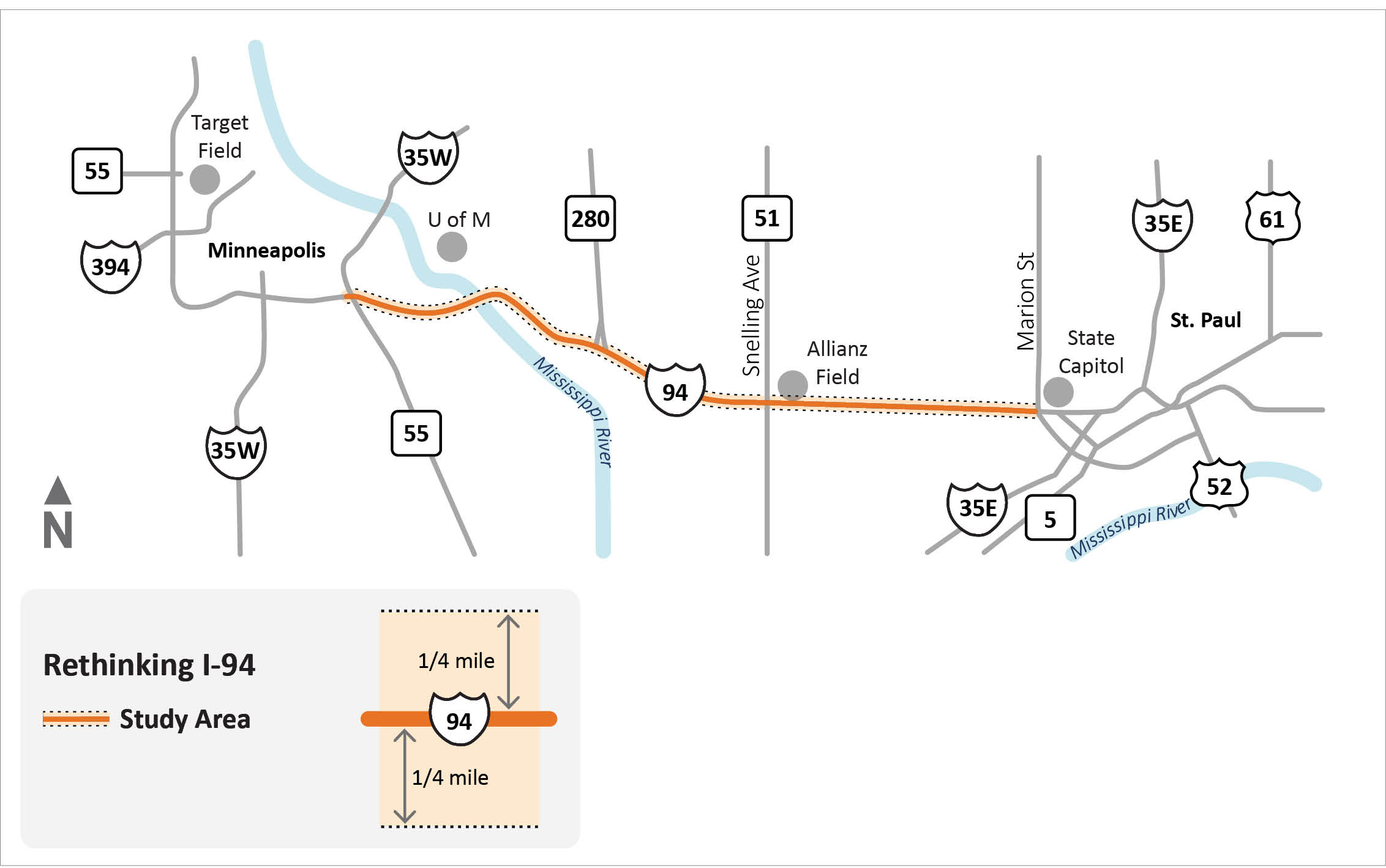
I-94 between Marion St. in St. Paul and Hwy 55/Hiawatha Ave. in Minneapolis
Phase 1 (2016-2018)
Rethinking I-94 — Minneapolis to St. Paul has finished this stage
A two-year technical research study and engagement activities, centered on the corridor, to establish the foundation for future planning and project work.
Phase 2 (2018-2028)
Rethinking I-94 — Minneapolis to St. Paul is currently at this stage
2020: Government agency engagement
2021-2025: Public engagement on draft scoping decision document
2025-2028: Environmental approvals
2028: Select preferred alternative
Full project schedule
this is an upcoming stage for Rethinking I-94 — Minneapolis to St. Paul



 University Avenue at Vandalia Avenue in 1953, with four travel lanes and paired streetcar tracks set in cobblestone ("University Avenue at Vandalia Avenue, St. Paul, Minnesota," 1953. Collection of the Minnesota Streetcar Museum
 Rondo Commemorative Plaza (4RM+ULA)
![Bird’s eye view of South Minneapolis in 1879, looking southwest from a point above the University of Minnesota’s East Bank Campus across the Mississippi River toward the intersection of Franklin Avenue (green) and Cedar Avenue (purple), with Riverside Avenue (red) in the foreground; the approximate Study Area is shaded in yellow (J.J. Stoner, “View of South Minneapolis, 1879,” [Madison, Wis: Beck and Pauli, 1879].](https://s3-us-west-1.amazonaws.com/ehq-production-us-california/e7126c5467df9dbd340648b78a4252ec8e529db2/original/1699914751/3310ae3f344c9c766aed0d66f36e44ea_Picture5.png?1699914751) Bird’s eye view of South Minneapolis in 1879, looking southwest from a point above the University of Minnesota’s East Bank Campus across the Mississippi River toward the intersection of Franklin Avenue (green) and Cedar Avenue (purple), with Riverside Avenue (red) in the foreground; the approximate Study Area is shaded in yellow (J.J. Stoner, “View of South Minneapolis, 1879,” [Madison, Wis: Beck and Pauli, 1879].
Bird’s eye view of South Minneapolis in 1879, looking southwest from a point above the University of Minnesota’s East Bank Campus across the Mississippi River toward the intersection of Franklin Avenue (green) and Cedar Avenue (purple), with Riverside Avenue (red) in the foreground; the approximate Study Area is shaded in yellow (J.J. Stoner, “View of South Minneapolis, 1879,” [Madison, Wis: Beck and Pauli, 1879]. 


![Bird’s eye view of South Minneapolis in 1879, looking southwest from a point above the University of Minnesota’s East Bank Campus across the Mississippi River toward the intersection of Franklin Avenue (green) and Cedar Avenue (purple), with Riverside Avenue (red) in the foreground; the approximate Study Area is shaded in yellow (J.J. Stoner, “View of South Minneapolis, 1879,” [Madison, Wis: Beck and Pauli, 1879].](https://s3-us-west-1.amazonaws.com/ehq-production-us-california/e7126c5467df9dbd340648b78a4252ec8e529db2/original/1699914751/3310ae3f344c9c766aed0d66f36e44ea_Picture5.png?1699914751%E2%80%9D)