
Alternatives
Overview
MnDOT is currently working with local and federal agency partners and working groups to evaluate the alternatives. MnDOT anticipates completing the alternatives evaluation and sharing these results with the public in late fall 2025. To learn more about the recommendations, please visit the Story Map. Select the “Evaluation and Recommendations” tab on the top of the page and scroll down to “Alternatives Moving Forward/Alternatives Not Moving Forward.”
The Scoping Document/Draft Scoping Decision Document (SD/DSDD) will be released in late fall 2025/early winter 2026. This document is used to identify key issues and concerns needing more study in the Tier 1 Environmental Impact Statement (EIS). It also officially identifies the alternatives recommended to move forward for study in the Tier 1 EIS. A formal public comment period will be scheduled late fall 2025/early winter 2026. MnDOT will collect comments and respond to them in the Scoping Decision Document (SDD) which will finalize the alternatives to be studied in the Tier 1 EIS and the areas of focus for additional study.
The alternatives were released in July 2023. The 10 alternatives combine highway and transit ideas, and included details like the roadway type, number of travel lanes, transit services and potential transit stop locations. Alternatives moving forward into the Tier 1 EIS will be further developed and refined based on feedback and additional technical review.
Details such as overpasses, intersections, ramps, frontage roads, parking, landscaping, corridor enhancements and transit stops will be studied in more detail in the Tier 1 EIS. Below are the alternatives released in July 2023.
Public engagement
From June to November of 2023, MnDOT hosted in-person and virtual public meetings, conducted an online survey, met with partners, community-based organizations and other key stakeholders, and attended multiple community events to collect public feedback on the alternatives. The feedback received will be used to refine and further develop alternatives. You can review a summary of the public engagement efforts that took place following the release of the alternatives.
A formal public comment period on the SD/DSDD is expected to be scheduled for late fall 2025/winter 2026. There will be several ways to comment on the SD/DSDD.
Alternatives survey responder demographics
An online survey about the alternatives was open from July - October 2023. The survey was designed for people to provide open-ended feedback on the 10 alternatives MnDOT presented in July. This summary presents the survey results broken down by demographics for further insights. People could complete the survey without providing their demographic information. As a result, there are inconsistencies in the number of responders across the various questions and categories.
In 2024 and 2025, MnDOT continued to meet with community members, interest groups, elected officials and cooperating agencies to share information and listen to feedback on the alternatives to inform their evaluation.
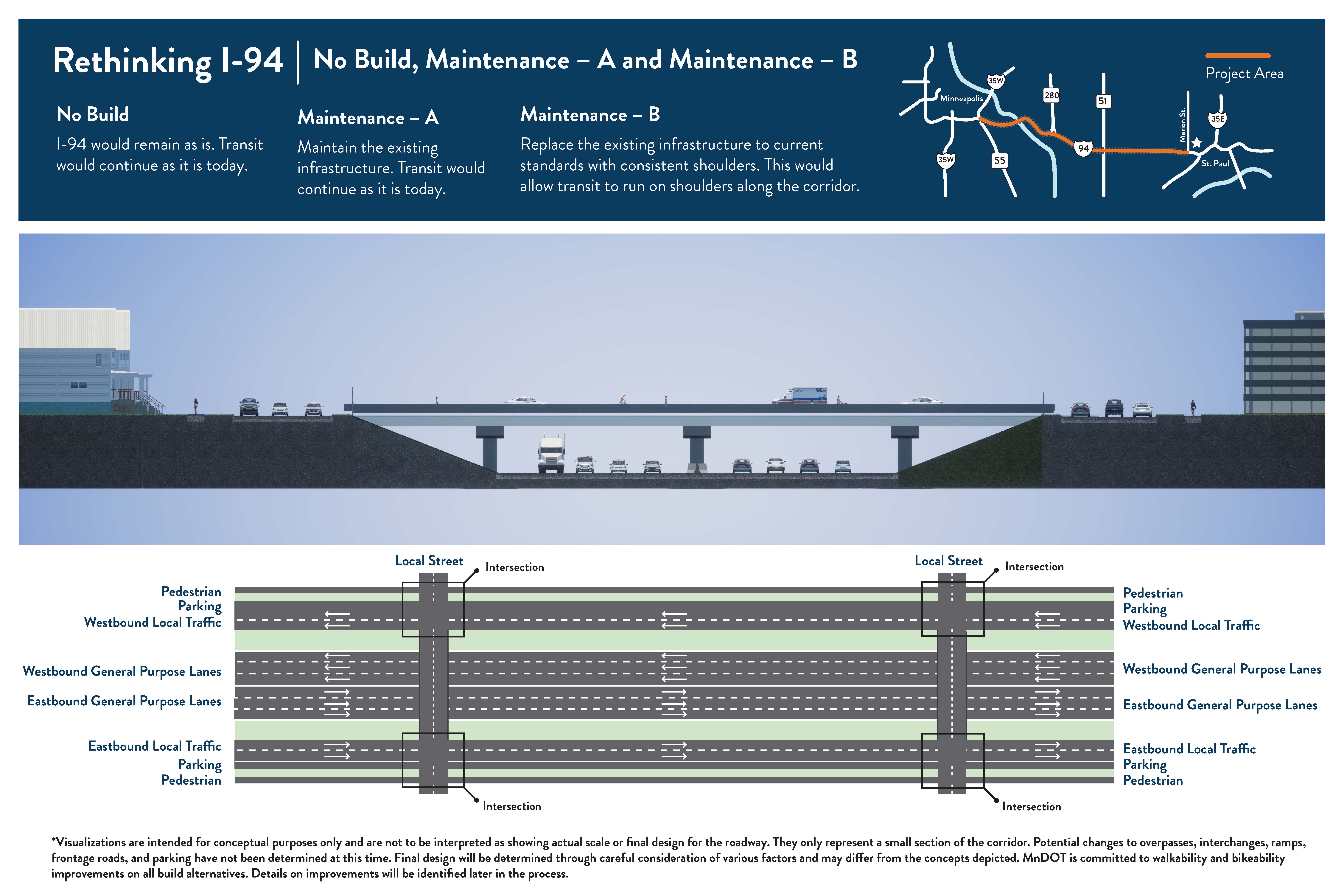
No Build, Maintenance – A, and Maintenance – B
No Build: I-94 would remain as is. Existing transit service would continue.
Maintenance – A: Maintain the existing infrastructure. Existing transit service would continue.
Maintenance – B: Replace the existing infrastructure to current standards with consistent shoulders. This would allow transit to run on bus shoulders between downtown Minneapolis and downtown St. Paul.
Download full-size handout (PDF).
Roadway type: Keeps a freeway with the same number of travel lanes.
Number of travel lanes: No changes from existing. Varies between three and four lanes in both directions.
Transit: No change from current service (Route 94 express bus). Maintenance B would extend bus shoulders to match conditions prior to I-35W bridge collapse.
Access changes: No changes from existing.
Pedestrian and bicycle: No major changes from existing. All crossings of I-94 would be a bridge – either pedestrian/bicycle-only or a roadway with pedestrian and/or bicycle facilities (such as a trail, sidewalk, or bike lanes). With Maintenance B, some new/improved facilities could be provided if bridges are replaced.
No Build, Maintenance – A
- The freeway would not be reconstructed. Maintenance A would allow for more in-depth maintenance activities.
- The overall number of lanes would not change. Currently the number of general purpose lanes varies between 3 and 4 in both directions.
- Existing express bus transit service (Metro Transit Route 94) would continue.
- No changes to pedestrian or bicycle facilities.
- No changes to interchanges or ramps along the freeway.
Maintenance – B
- The freeway would be reconstructed with the same number of lanes.
- Existing express bus transit service (Metro Transit Route 94) would continue. Current bus shoulders would be extended to connect downtown Minneapolis and downtown St. Paul.
- Some new/improved pedestrian or bicycle facilities could be provided if bridges are replaced.
- No changes to interchanges or ramps along the freeway.
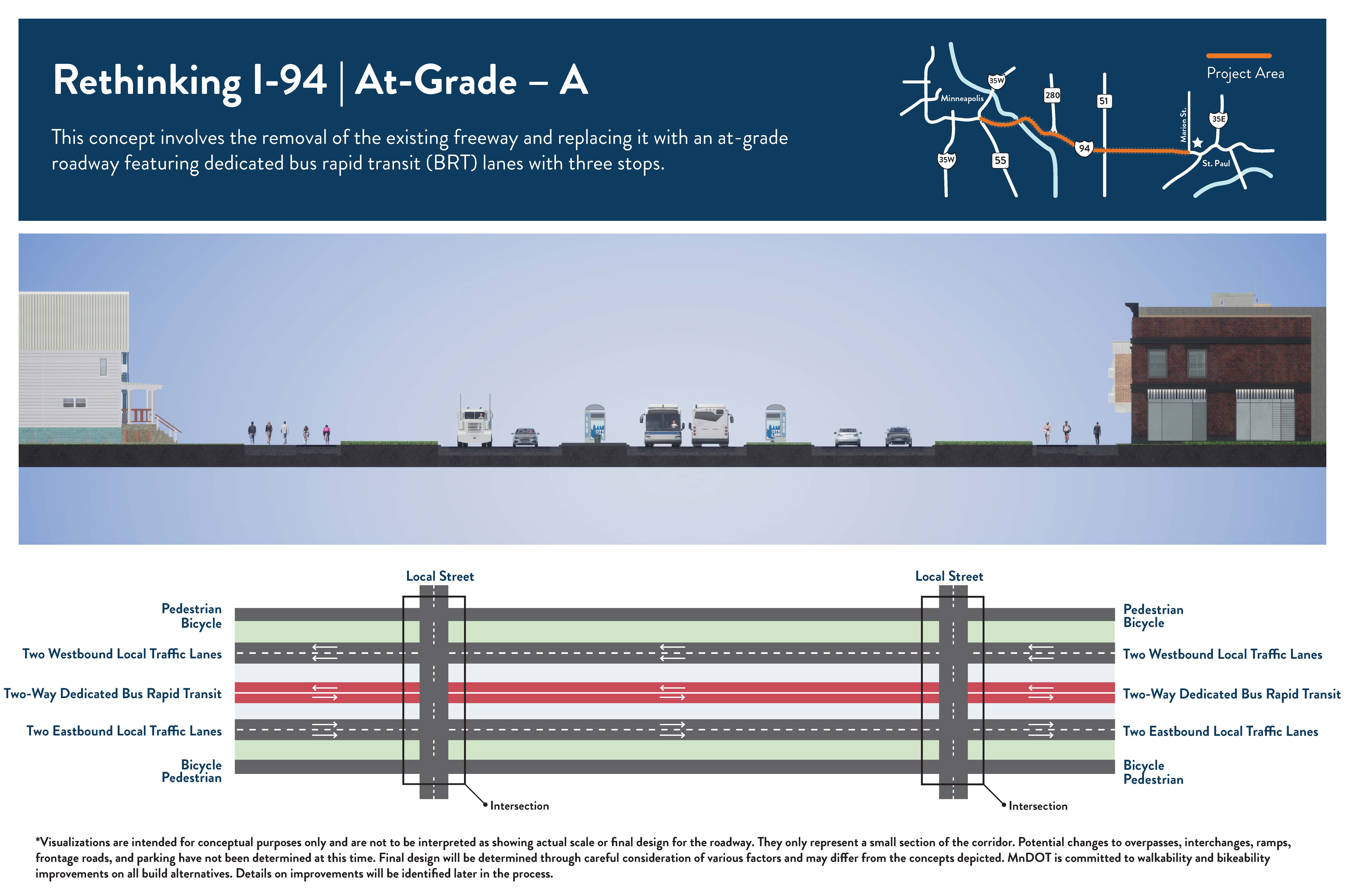
At-Grade – A
This concept involves the removal of the existing freeway, filling in the corridor, and constructing a new at-grade roadway. It also features dedicated bus rapid transit (BRT) lanes in the center with up to three stops.
Roadway type: Removes the freeway (and Interstate designation within project area). Constructs at-grade roadway in same location.
Number of travel lanes: 2 lanes in each direction for all vehicles and 1 dedicated bus rapid transit (BRT) lane in each direction in the center of the roadway.
Transit: BRT in dedicated lanes in the center of the roadway with up to 3 stops (Locations to be determined).
Access changes: Current interchanges, on/off ramp locations, and other bridges and underpasses would be converted to intersections with the new roadway (intersection designs to be determined). Some bridges for cross traffic may remain due to the elevations of existing roadways. Frontage roads/side streets may be modified or removed.
Pedestrian and bicycle: Most crossings would be “at-grade” (people would use crosswalks to get across the lanes of traffic) because current bridges and underpasses would be converted to intersections. Pedestrian/bicycle bridges over the road may be possible in some areas. There is potential to include pedestrian and/or bicycle facilities (such as a trail, sidewalk, or bike lanes) along the north and/or south sides of the new roadway. Specific changes are to be determined.
Download full-size handout (PDF).
- The freeway would be removed and replaced with a road that would have 2 lanes for all vehicles and 1 dedicated transit lane (for buses only) in both directions.
- The overall number of lanes is reduced. Currently the number of general purpose lanes varies between 3 and 4 in both directions.
- Transit will operate in the dedicated lanes in the center of the roadway with up to 3 stops.
- There would likely be a mix of at-grade pedestrian and bicycle crossings (people would use crosswalks to get across the lanes of traffic) and pedestrian/bicycle bridges depending on the location.
- New pedestrian and/or bicycle facilities are possible.
- Current interchanges and most crossing locations would be converted to intersections.
- In some locations a bridge for railroad crossings, pedestrian and bicycle facilities, or local roadways may remain due to the terrain.
- Current frontage roads/side streets may be removed or incorporated into the at-grade design.
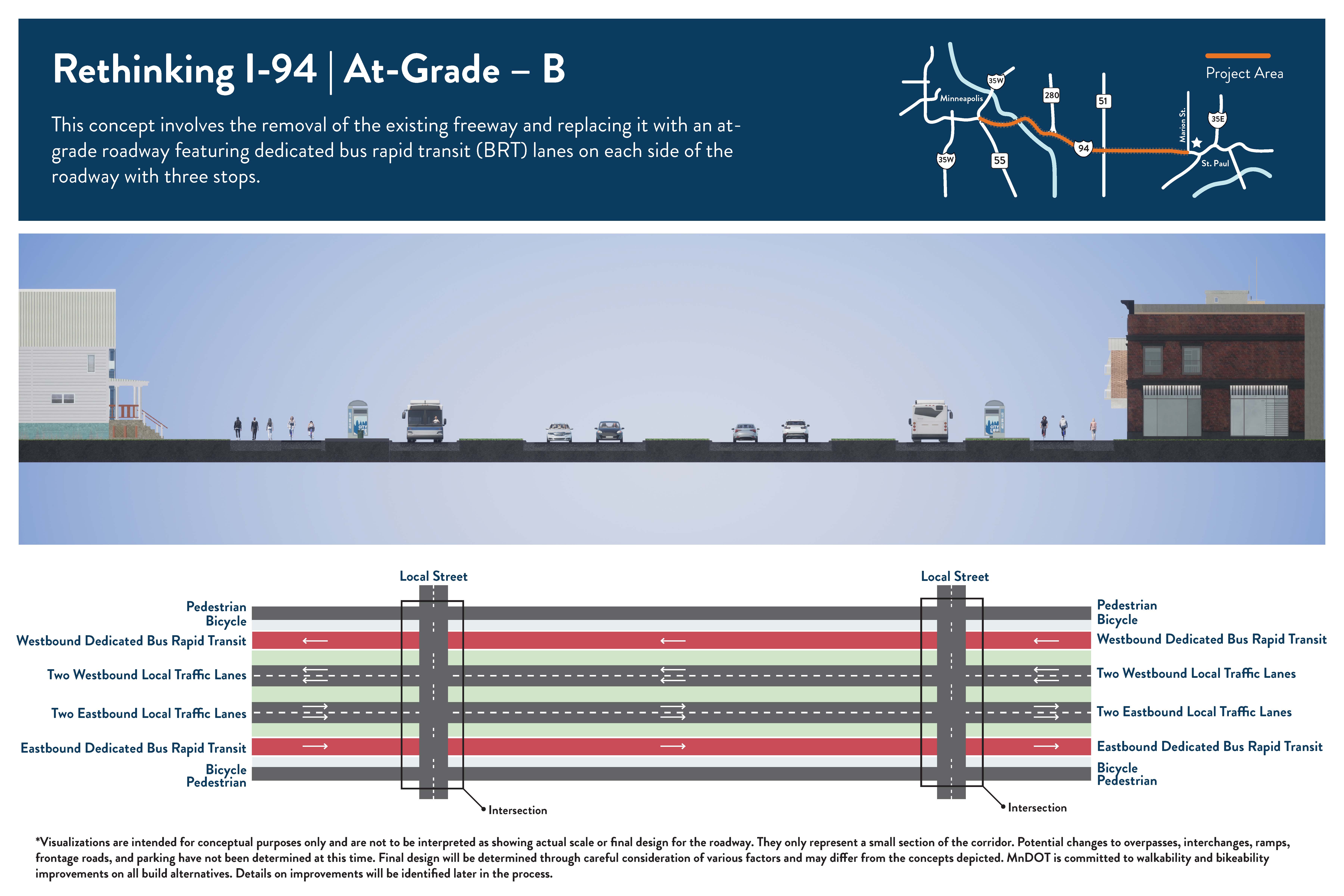
At-Grade – B
This concept involves the removal of the existing freeway, filling in the corridor, and constructing a new at-grade roadway. It also features dedicated bus rapid transit (BRT) lanes on the outside of the roadway with up to three stops.
Roadway type: Removes the freeway (and Interstate designation within project area). Constructs at-grade roadway in same location.
Number of travel lanes: 2 lanes in each direction for all vehicles and 1 dedicated bus rapid transit (BRT) lane in each direction on the outside of the roadway.
Transit: BRT in dedicated lanes on the outside of the roadway with up to 3 stops (Locations to be determined).
Access changes: Current interchanges, on/off ramp locations, and other bridges and underpasses would be converted to intersections with the new roadway (intersection designs to be determined). Some bridges for cross traffic may remain due to the elevations of existing roadways. Frontage roads/side streets may be modified or removed.
Pedestrian and bicycle: Most crossings would be “at-grade” (people would use crosswalks to get across the lanes of traffic) because current bridges and underpasses would be converted to intersections. Pedestrian/bicycle bridges over the road may be possible in some areas. There is potential to include pedestrian and/or bicycle facilities (such as a trail, sidewalk, or bike lanes) along the north and/or south sides of the new roadway. Specific changes are to be determined.
Download full-size handout (PDF).
- The freeway would be removed and replaced with a road that would have 2 lanes for all vehicles and 1 dedicated transit lane (for buses only) in both directions.
- The overall number of lanes is reduced. Currently the number of general purpose lanes varies between 3 and 4 in both directions.
- Transit will operate in the dedicated lanes on the outside of the roadway with up to 3 stops.
- There would likely be a mix of at-grade pedestrian and bicycle crossings (people would use crosswalks to get across the lanes of traffic) and pedestrian/bicycle bridges depending on the location.
- New pedestrian and/or bicycle facilities are possible.
- Current interchanges and most crossing locations would be converted to intersections.
- In some locations a bridge for railroad crossings, pedestrian and bicycle facilities, or local roadways may remain due to the terrain.
- Current frontage roads/side streets may be removed or incorporated into the at-grade design.
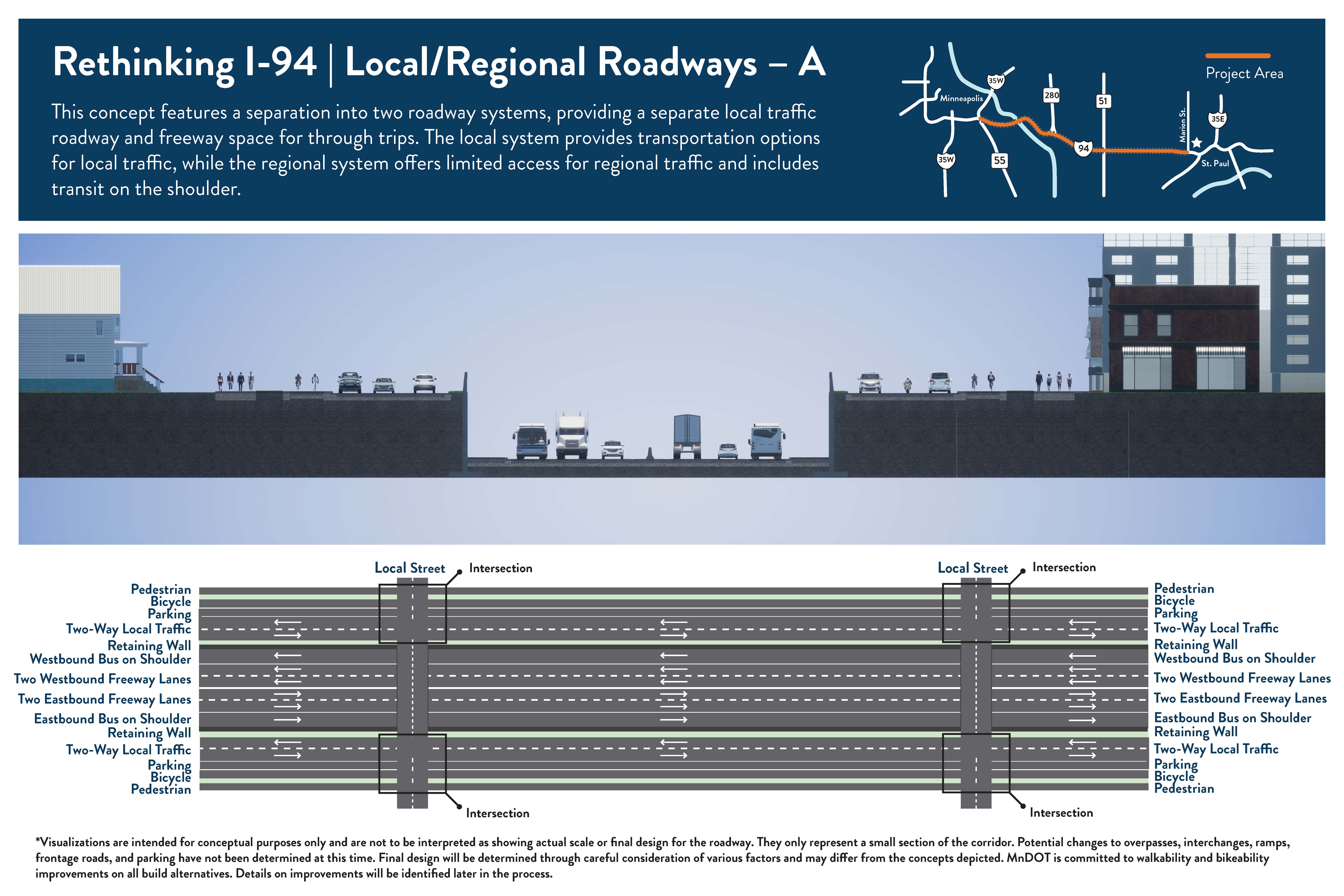
Local/Regional Roadways – A
This concept features a separation into two roadway systems, providing a local traffic roadway and freeway space for through trips. The local system provides transportation options for local traffic, while the regional system offers limited access for regional traffic and includes transit on the shoulder.
Roadway type: Keeps a reduced size freeway. Constructs local roadways on both sides.
Number of travel lanes: Freeway: 2 lanes in each direction for all vehicles and a shoulder that buses can use in each direction. Local Roadways: 1 lane in each direction for all vehicles (on both sides of freeway).
Transit: Transit on shoulders on the freeway (Stop locations to be determined). Local bus route changes to be determined.
Access changes: Access changes to be determined. Interchanges will be limited and some will be removed. Potential to modify interchanges in some locations including on/off ramp changes or removal. Potential changes to frontage roads/side streets may occur in some locations.
Pedestrian and bicycle: To be determined. All crossings of I-94 would be a bridge – either pedestrian/bicycle-only or a roadway with pedestrian and/or bicycle facilities (such as a trail, sidewalk, or bike lanes). Potential to include pedestrian and/or bicycle facilities on roads that go east-west (like I-94) to the north or south of I-94 since bicyclists and pedestrians are not allowed on Interstate routes.
Download full-size handout (PDF).
- The freeway would be reconstructed and narrowed to have 2 general purpose lanes (all vehicles can use) and a bus shoulder in both directions.
- Two-way local streets will be constructed on each side of the freeway, with speed limits expected to be lower than the freeway.
- Current frontage roads/side streets may be removed or incorporated into the local roadway design.
- The overall number of freeway lanes is reduced throughout the project corridor. Currently the number of general purpose lanes varies between 3 and 4 in both directions.
- Transit will operate on the shoulders on the regional system. Local bus route changes to be determined.
- Current pedestrian facilities would be improved, and additional pedestrian and bicycle crossings will be considered.
- New pedestrian and/or bicycle facilities along the new local roadways are possible.
- Current interchanges along the freeway would be modified or removed to improve mobility and safety. Most existing on/off ramps along the freeway would be removed.
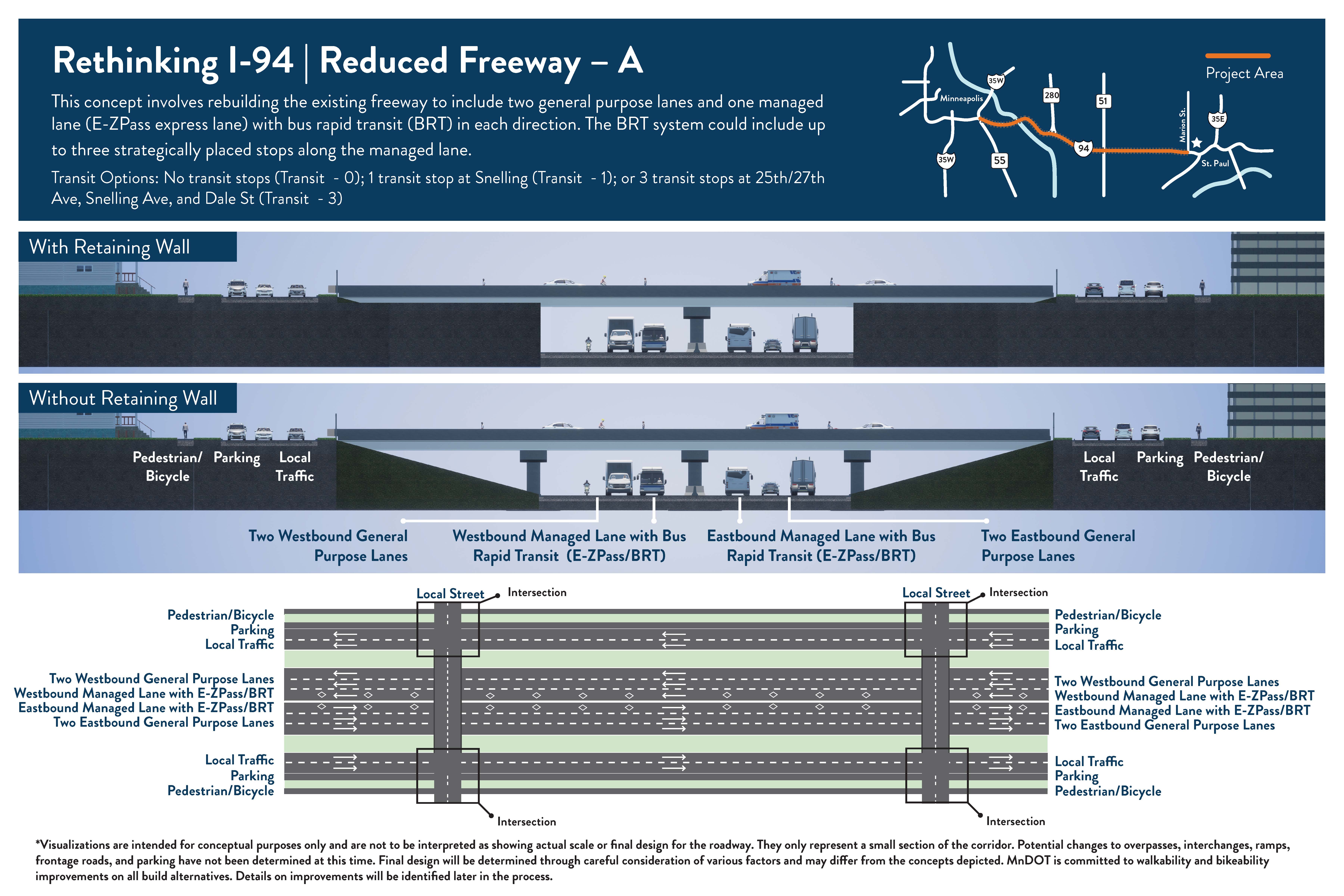
Reduced Freeway – A
This concept involves rebuilding the existing freeway to include 2 general purpose lanes and 1 managed lane with bus rapid transit (BRT) in each direction. The BRT system could include up to three stops.
Roadway type: Keeps a freeway. Reduces the number of travel lanes.
Number of travel lanes: 2 lanes in each direction for all vehicles and 1 managed lane in each direction (for buses, people that carpool, and those willing to pay).
Transit: Bus rapid transit (BRT) in managed lanes with no stops; 1 stop at Snelling Ave; or 3 stops at 25th/27th Ave, Snelling Ave, and Dale St (Final locations to be determined).
Access changes: Access changes to be determined. Potential to modify interchanges in some locations including on/off ramp changes or removal. Potential changes to frontage roads/side streets may occur in some locations.
Pedestrian and bicycle: To be determined. All crossings of I-94 would be a bridge – either pedestrian/bicycle-only or a roadway with pedestrian and/or bicycle facilities (such as a trail, sidewalk, or bike lanes). Potential to include pedestrian and/or bicycle facilities on roads that go east-west (like I-94) to the north or south of I-94 (frontage roads) since bicyclists and pedestrians are not allowed on Interstate routes.
Download full-size handout (PDF).
- The freeway would be reconstructed to have 2 general purpose lanes (all vehicles can use) and 1 managed lane (for buses, those that carpool, and those willing to pay) in both directions. Outside of peak hours, managed lanes operate as general purpose lanes.
- The overall number of lanes is reduced throughout the project corridor. Currently the number of general purpose lanes varies between 3 and 4 in both directions.
- Transit will operate in the managed lanes.
- Current pedestrian facilities would be improved, and additional pedestrian and bicycle crossings will be considered.
- Interchanges and ramps along the freeway would be studied to improve mobility and safety.
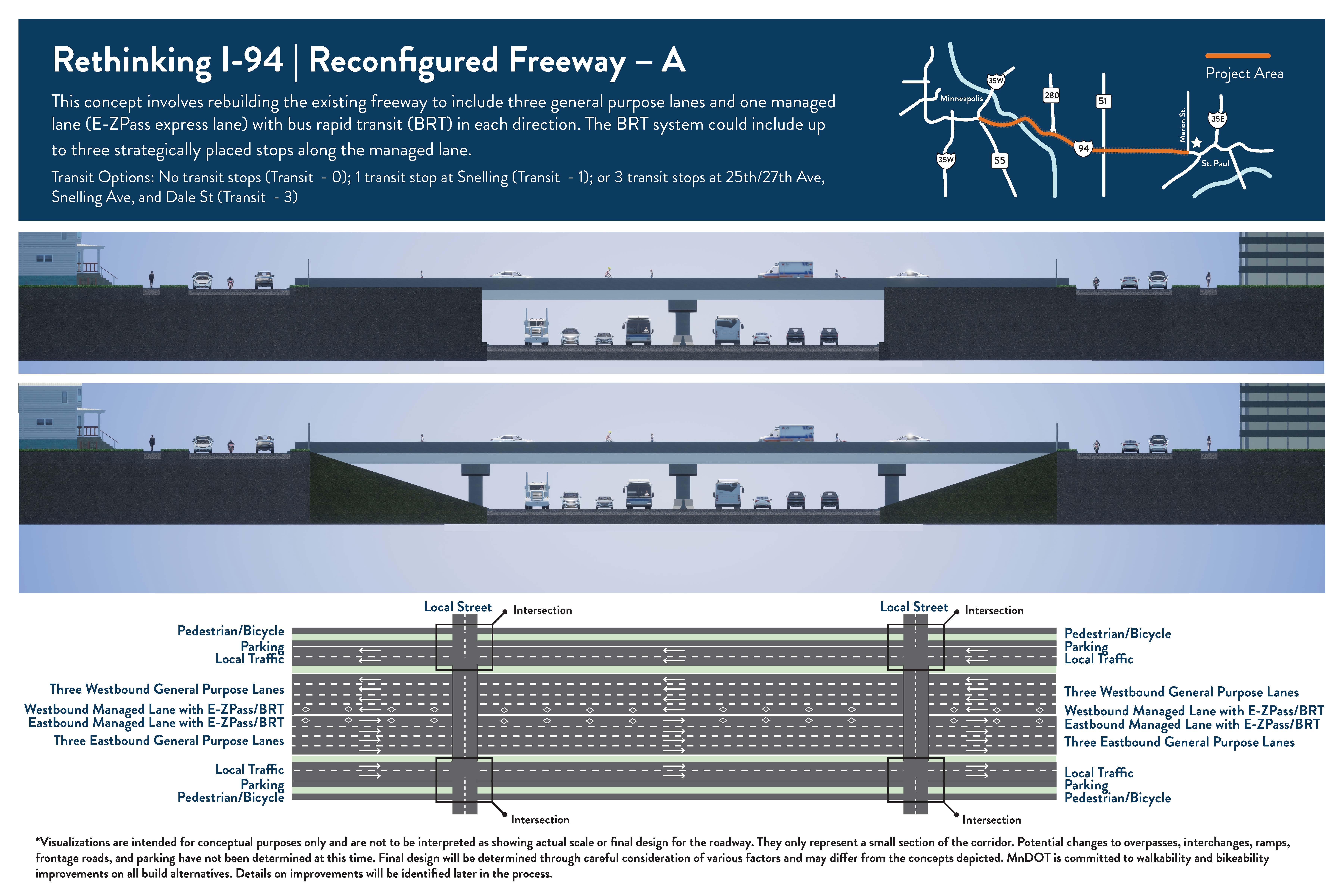
Reconfigured Freeway – A
This concept involves rebuilding the existing freeway to include 3 general purpose lanes and 1 managed lane with bus rapid transit (BRT) in each direction. The BRT system could include up to three stops along the managed lane.
Roadway type: Keeps a freeway. Changes the type of travel lanes available.
Number of travel lanes: 3 lanes in each direction for all vehicles and 1 managed lane in each direction (for buses, people that carpool, and those willing to pay).
Transit: Bus rapid transit (BRT) in managed lanes with no stops; 1 stop at Snelling Ave; or 3 stops at 25th/27th Ave, Snelling Ave, and Dale St (Final locations to be determined).
Access changes: Access changes to be determined. Potential to modify interchanges in some locations including on/off ramp changes or removal. Potential changes to frontage roads/side streets may occur in some locations.
Pedestrian and bicycle: To be determined. All crossings of I-94 would be a bridge – either pedestrian/bicycle-only or a roadway with pedestrian and/or bicycle facilities (such as a trail, sidewalk, or bike lanes). Potential to include pedestrian and/or bicycle facilities on roads that go east-west (like I-94) to the north or south of I-94 (frontage roads) since bicyclists and pedestrians are not allowed on Interstate routes.
Download full-size handout (PDF).
- The freeway would be reconstructed to have 3 general purpose lanes (all vehicles can use) and 1 managed lane (for buses, those that carpool, and those willing to pay) in both directions. Outside of peak hours, managed lanes operate as general purpose lanes.
- The overall number of lanes stays the same throughout the project corridor. Currently the number of general purpose lanes varies between 3 and 4 in both directions.
- Transit will operate in the managed lanes.
- Current pedestrian facilities would be improved, and additional pedestrian and bicycle crossings will be considered.
- Interchanges and ramps along the freeway would be studied to improve mobility and safety.
Expanded Freeway – A
This concept involves rebuilding the existing freeway and adding 1 managed lane with bus rapid transit (BRT) in each direction. The BRT system could include up to three stops. The total number of lanes will vary because the current number of lanes also varies.
Roadway type: Keeps a freeway. Adds a new managed lane.
Number of travel lanes: 3-4 lanes in each direction for all vehicles and 1 managed lane in each direction (for buses, people that carpool, and those willing to pay).
Transit: Bus rapid transit (BRT) in managed lanes with no stops; 1 stop at Snelling Ave; or 3 stops at 25th/27th Ave, Snelling Ave, and Dale St (Final locations to be determined).
Access changes: Access changes to be determined. Potential to modify interchanges in some locations including on/off ramp changes or removal. Potential changes to frontage roads/side streets may occur in some locations.
Pedestrian and bicycle: To be determined. All crossings of I-94 would be a bridge – either pedestrian/bicycle-only or a roadway with pedestrian and/or bicycle facilities (such as a trail, sidewalk, or bike lanes). Potential to include pedestrian and/or bicycle facilities on roads that go east-west (like I-94) to the north or south of I-94 (frontage roads) since bicyclists and pedestrians are not allowed on Interstate routes.
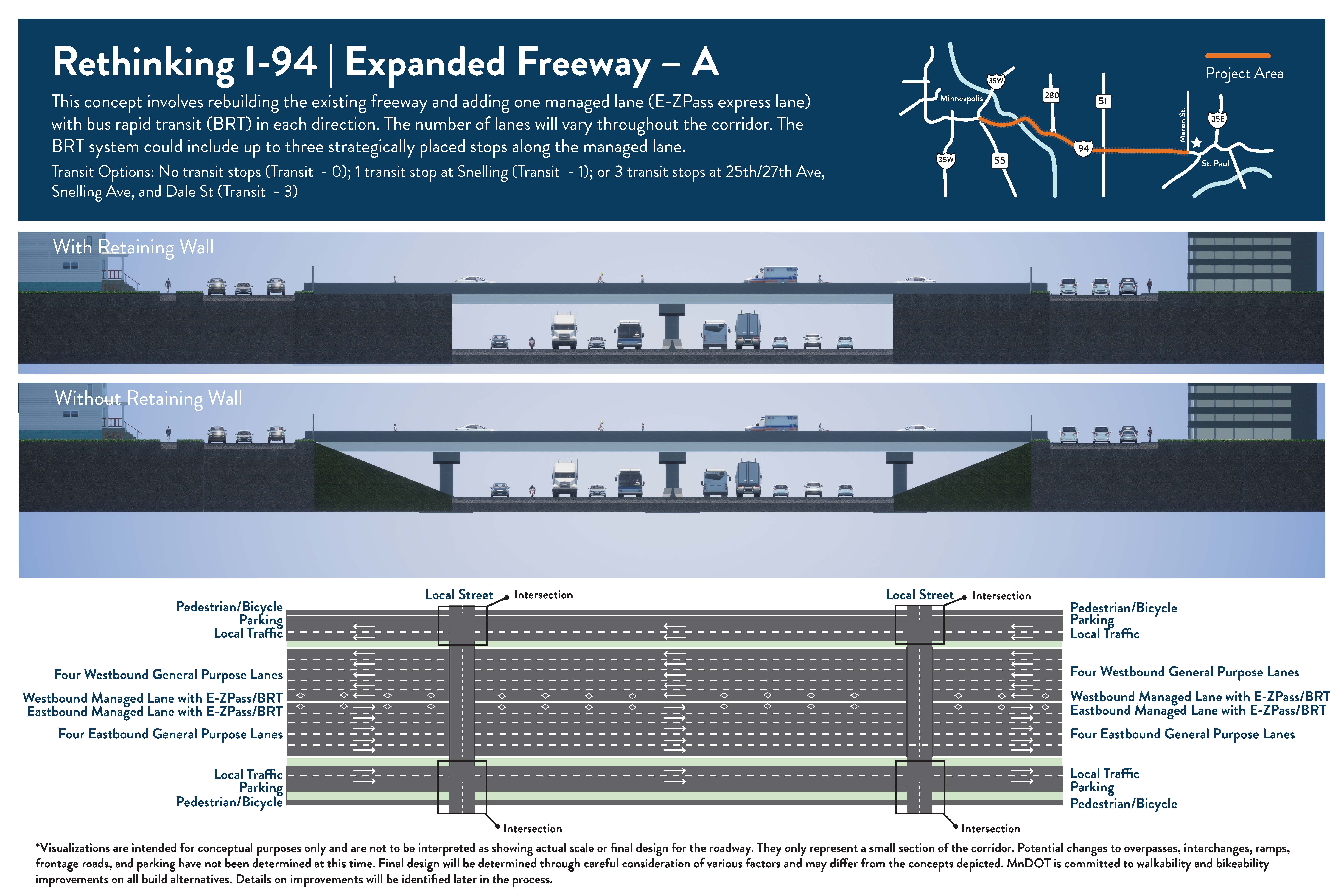
- The freeway would be reconstructed to have 3-4 general purpose lanes (all vehicles can use) and 1 managed lane (for buses, those that carpool, and those willing to pay) in both directions. The managed lane would be an addition to the current number of lanes. Outside of peak hours, managed lanes operate as general purpose lanes.
- The overall number of lanes will increase by 1 throughout the project corridor. Currently the number of general purpose lanes varies between 3 and 4 in both directions.
- Transit will operate in the managed lanes.
- Current pedestrian facilities would be improved, and additional pedestrian and bicycle crossings will be considered.
- Interchanges and ramps along the freeway would be studied to improve mobility and safety.
Expanded Freeway – B
This concept involves rebuilding the existing freeway and adding 1 new lane (for all vehicles) and extending the bus shoulder along the entire corridor in each direction. The total number of lanes will increase.
Roadway type: Keeps a freeway. Adds a new lane for all vehicles and extends bus shoulders.
Number of travel lanes: 4-5 lanes in each direction for all vehicles.
Transit: Bus shoulders between downtown Minneapolis and downtown St. Paul with 1 stop at Snelling Ave.
Access changes: Access changes to be determined. Potential to modify interchanges in some locations including on/off ramp changes or removal. Potential changes to frontage roads/side streets may occur in some locations.
Pedestrian and bicycle: To be determined. All crossings of I-94 would be a bridge – either pedestrian/bicycle-only or a roadway with pedestrian and/or bicycle facilities (such as a trail, sidewalk, or bike lanes). Potential to include pedestrian and/or bicycle facilities on roads that go east-west (like I-94) to the north or south of I-94 (frontage roads) since bicyclists and pedestrians are not allowed on Interstate routes.
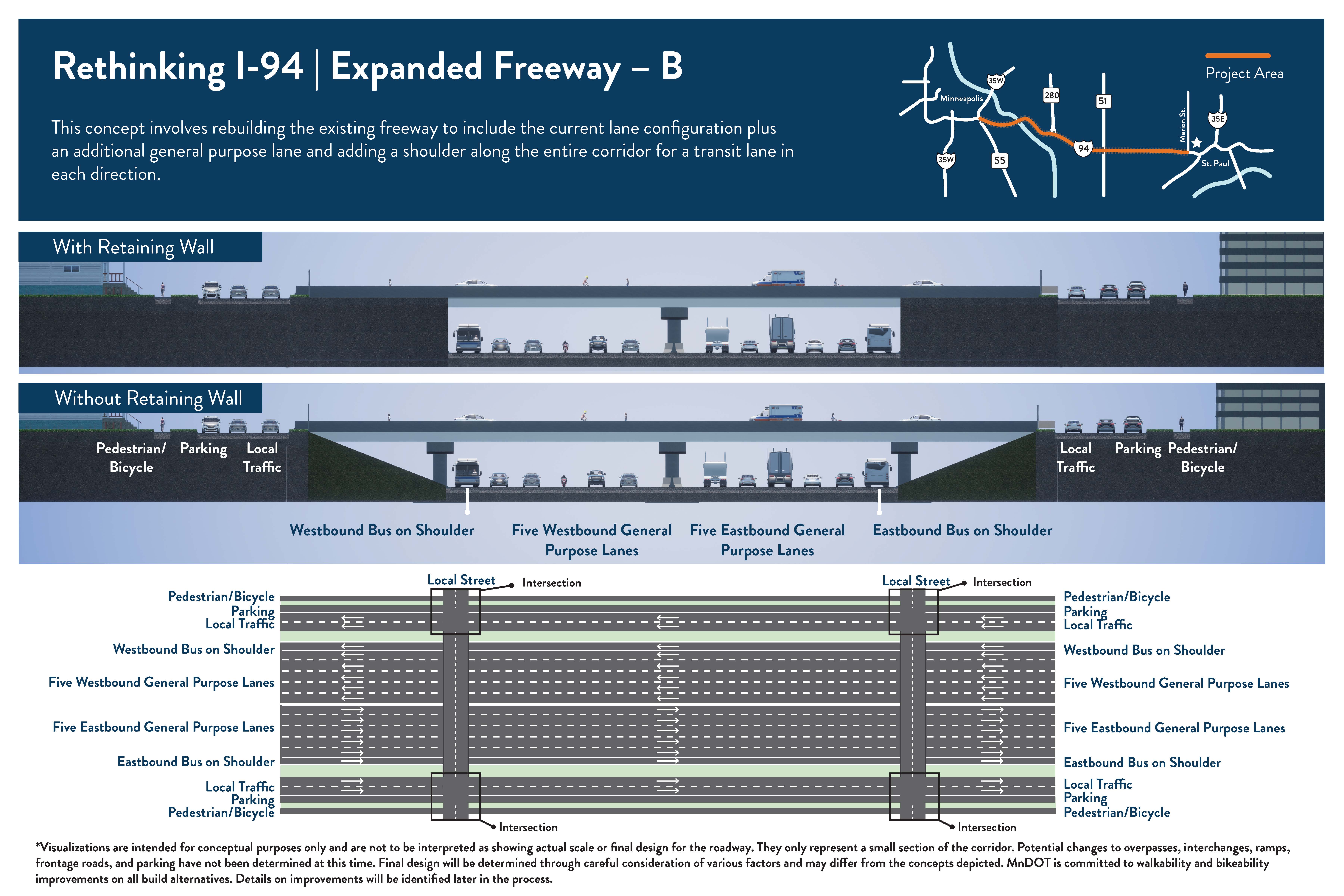
- The freeway would be reconstructed to have 4-5 general purpose lanes (all vehicles can use) and a consistent shoulder in both directions.
- The overall number of lanes will increase by 1 throughout the project corridor. Currently the number of general purpose lanes varies between 3 and 4 in both directions.
- Transit will operate in shoulders. Current bus shoulders would be extended to connect downtown Minneapolis and downtown St. Paul.
- Current pedestrian facilities would be improved, and additional pedestrian and bicycle crossings will be considered.
- Interchanges and ramps along the freeway would be studied to improve mobility and safety.

Thank you for your contribution!
Help us reach out to more people in the community
Share this with family and friends