Skip to content

Committee Feedback

Active Transportation Locations

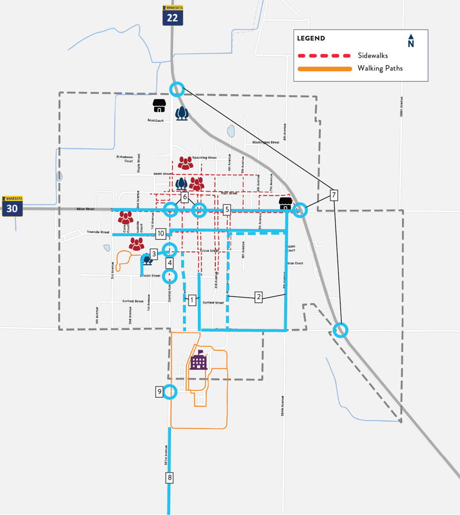
On September 16, the Mapleton Active Transportation Committee met at the Mapleton Community Center to identify and prioritize the locations, routes, and connections where Mapleton can provide safer, more comfortable walking and biking. Ten locations were identified, shown on the map. The numbers labeling each location are for identification purposes only, and do not represent importance or priority.
Instructions

For each of the project locations please read the description of the suggested improvement, see the photo example of what the suggested improvement could look like, and answer the following questions:

  • What level of priority should this location be assigned? (i.e., when should actions be taken to implement this suggestion?)
  • What questions or changes do you have concerning this location and suggested improvement?

#1. 1st or 2nd Ave bikeway & sidewalk to Maple River Schools.

This suggestion is to install a painted walking and biking lane on one side of either 1st Ave or 2nd Ave to provide a safe link between existing sidewalks and the school.

1.  

What level of priority is this connection (#1)?

Maximum 5,000 characters

0/5,000

#2. Connected route between school and Dollar General Market, utilizing Borchert St/8th Ave or 4th Ave/Troendle St

This suggestion is to install a biking and walking path connecting Maple River Schools and the Dollar General Market. A short-term solution is a painted walk/bike lane on 4th Ave and Troendle St. A long-term solution is a paved trail along Borchert St and 8th Ave.

3.  

What level of priority is this connection (#2)?

Maximum 5,000 characters

0/5,000

#3. Shared walking/biking/vehicle space on Grove St in Heritage Park

This suggestion is to visually reinforce the section of Grove St within Heritage Park as a shared “plaza” for people to walk, bike, or very cautiously drive. A short term solution is to use paint, bike racks, and concrete barriers or planters to slow vehicle traffic. A long-term solution could be to install a gate or bollards to discourage vehicles from cutting through the park.

5.  

What level of priority is this connection (#3)?

Maximum 5,000 characters

0/5,000

#4. Crossings of Central Ave to Heritage Park

This suggestion is to create high-visibility crossings of Central Ave for people to get to Heritage Park by walking or biking. Improved crossings could be located at Grove St, Lincoln St, or both. This improvement will require coordination with Blue Earth County.

7.  

What level of priority is this connection (#4)?

Maximum 5,000 characters

0/5,000

#5. Separate bikeway along Silver St (Hwy 30)

This suggestion is to reallocate width on Silver St (Hwy 30) to install a comfortable bikeway separated from vehicle traffic. This improvement will require coordination with MnDOT.

9.  

What level of priority is this connection (#5)?

Maximum 5,000 characters

0/5,000

#6. Crossings of Silver St (Hwy 30) at Central Ave and 2nd Ave

This suggestion is to install safer, more comfortable crossings of Silver St (Hwy 30) at Central Ave and 2nd Ave, and potentially other cross-streets. Short-term solutions could use paint and flexible delineators to shorten crossing lengths, and install additional signage. Long-term solutions could modify the curb line to narrow the roadway and shorten crossing lengths, and install flashing pedestrian beacons. This improvement will require coordination with Blue Earth County and MnDOT.

11.  

What level of priority is this connection (#6)?

Maximum 5,000 characters

0/5,000

#7. Crossings and intersection skew on Hwy 22 at Central Ave, Silver St, and Borchert St

This suggestion is to use upcoming reconstruction of Hwy 22 to install safer crossings of Hwy 22 and eliminate the intersection skew at Central Ave, Silver St (Hwy 30) and Borchert St. This improvement will require coordination with Blue Earth County and MnDOT.

13.  

What level of priority is this connection (#7)?

Maximum 5,000 characters

0/5,000

#8. Shared-use path to Daly Park

This suggestion is to install a separated walking and biking bath along County Road 7 and 111th St to connect Mapleton to Daly Park. This improvement will require coordination with Blue Earth County.

15.  

What level of priority is this connection (#8)?

Maximum 5,000 characters

0/5,000

#9. Traffic calming south “Gateway” to Mapleton

This suggestion is to install a feature that welcomes people to Mapleton and slows vehicle traffic near the Mapleton’s southern city boundary adjacent to Maple River Schools. This feature could include signage, landscaping, narrowing the width of the roadway, installing a roundabout at the Maple River Schools driveway entrance, or other improvements. This improvement will require coordination with Blue Earth County.

17.  

What level of priority is this connection (#9)?

Maximum 5,000 characters

0/5,000

#10. Complete sidewalks and add bikeway along Troendle St

This suggestion is to implement a safer biking and walking route along Troendle St. This route would make it easier for people to walk and bike east and west across Mapleton. A short-term solution could be a painted walking and biking lane. A long-term solution could be construction of continuous sidewalk and bike lanes.

19.  

What level of priority is this connection (#10)?

Maximum 5,000 characters

0/5,000

Maximum 255 characters

0/255