Hwy 7 study — Hopkins to St. Bonifacius
Study update – Recommended improvements
The comment period for the recommended improvements for the Hwy 7 study closed on Nov. 30. Thank you to everyone who provided comments. Comments are being reviewed and will be used to guide future design updates in the study area. Learn more about the recommended improvements. Sign up for email updates to receive updates on the study.
About this study
We  View full-size mapare studying Hwy 7 from Hopkins Crossroad in Hopkins to the western Hennepin County line in St. Bonifacius.
This study will seek to understand the transportation needs of all users, identify opportunities for future improvements, establish a shared vision for improvement concepts among study partners, and develop and evaluate these concepts to inform the design of facilities that will be upgraded as part of a pavement resurfacing project planned for 2029 from the Hennepin/Carver County line in the City of St. Bonifacius to .2 miles east of Mill St. in the City of Shorewood.
From November 2021 through June 2022, a road safety audit was conducted on Hwy 7 from Hwy 100 in St. Louis Park to Carver Co. Rd. 33 in Hollywood Township. This audit recommended that a full planning study be completed to develop a plan for future improvements that includes access management, pedestrian and bicycle crossings, accessibility, highway signs, roadway signals, and lighting. This planning study will be informed in part by the road safety audit completed on this road.
Summary of work
- Assess and document existing conditions
- Ask people to share their transportation experiences and needs
- Produce a document that identifies transportation needs and opportunities in the study area
- Develop and evaluate recommended ideas for improvements, and get public input
- Develop next steps for advancing the recommended improvements
Get involved
As a part of this planning study, we will be gathering input from community through public meetings, events and surveys.
- Sign up for email updates to receive information on how you can share your input and stay up to date on this study
- Leave a comment or question
Study update – Recommended improvements
The comment period for the recommended improvements for the Hwy 7 study closed on Nov. 30. Thank you to everyone who provided comments. Comments are being reviewed and will be used to guide future design updates in the study area. Learn more about the recommended improvements. Sign up for email updates to receive updates on the study.
About this study
We  View full-size mapare studying Hwy 7 from Hopkins Crossroad in Hopkins to the western Hennepin County line in St. Bonifacius.
This study will seek to understand the transportation needs of all users, identify opportunities for future improvements, establish a shared vision for improvement concepts among study partners, and develop and evaluate these concepts to inform the design of facilities that will be upgraded as part of a pavement resurfacing project planned for 2029 from the Hennepin/Carver County line in the City of St. Bonifacius to .2 miles east of Mill St. in the City of Shorewood.
From November 2021 through June 2022, a road safety audit was conducted on Hwy 7 from Hwy 100 in St. Louis Park to Carver Co. Rd. 33 in Hollywood Township. This audit recommended that a full planning study be completed to develop a plan for future improvements that includes access management, pedestrian and bicycle crossings, accessibility, highway signs, roadway signals, and lighting. This planning study will be informed in part by the road safety audit completed on this road.
Summary of work
- Assess and document existing conditions
- Ask people to share their transportation experiences and needs
- Produce a document that identifies transportation needs and opportunities in the study area
- Develop and evaluate recommended ideas for improvements, and get public input
- Develop next steps for advancing the recommended improvements
Get involved
As a part of this planning study, we will be gathering input from community through public meetings, events and surveys.
- Sign up for email updates to receive information on how you can share your input and stay up to date on this study
- Leave a comment or question
-
Recommended improvements
Share Recommended improvements on Facebook Share Recommended improvements on Twitter Share Recommended improvements on Linkedin Email Recommended improvements linkThe study team is ready to share the recommended improvements for Hwy 7. Community input and technical analysis were used to evaluate the design alternatives and help select the recommended improvement.
Recommended improvements video
Learn more about the recommendations by watching the recommended improvements video.
Segment 1 recommendation: Roundabouts
Hwy 7 from the Hennepin/Carver County line in St. Bonifacius to Hwy 41 in Shorewood
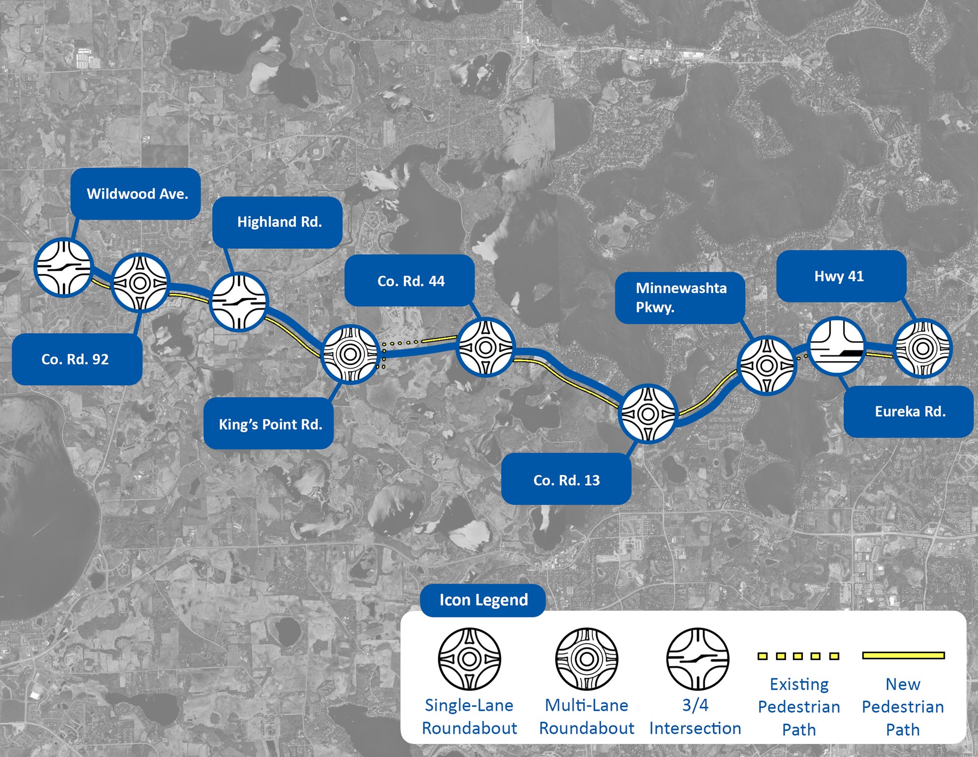 View full-sizeKey features
 - Median barrier between the intersections
- ¾ intersection at Wildwood Ave., Highland Rd. and Eureka Rd.
- Single-lane roundabouts at Hwy 92, Hwy 44, Hwy 13 and Minnewashta Pkwy.
- Multi-lane roundabouts at King’s Point Rd. and Hwy 41
- Multi-use trail along the entire segment
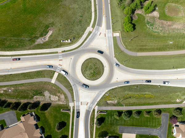 Example of a roundabout.
 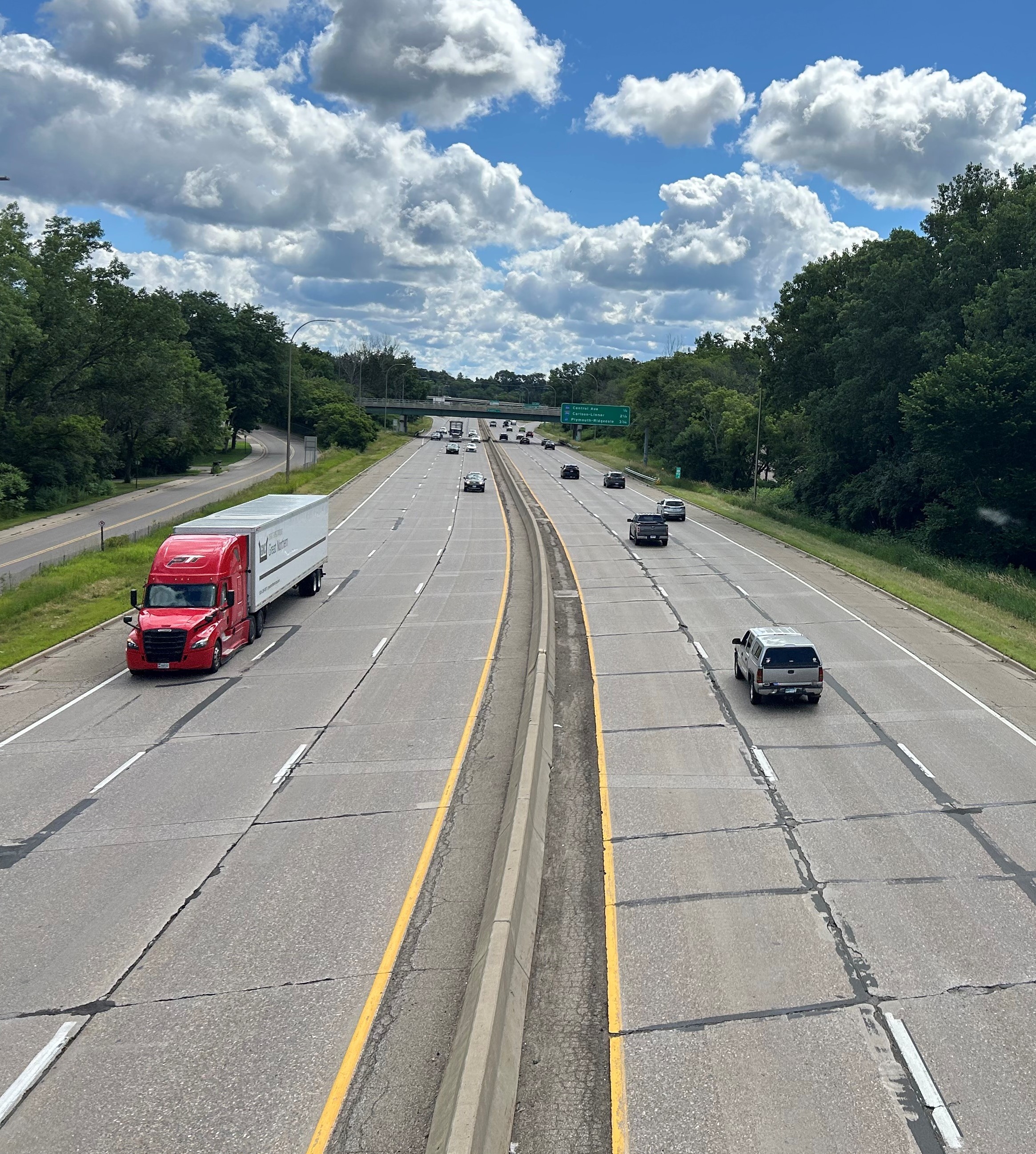 Example of a median barrier between intersections.
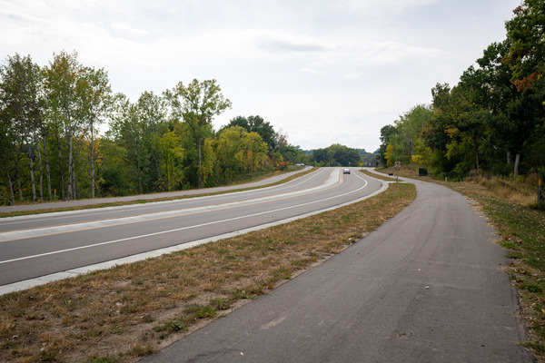 Example of a multi-use trail along the highway. Why was this selected?
- Roundabouts were selected based on their ability to address the highway’s needs for vehicle safety and mobility, and improvements for walking and biking.
- Roundabouts are safer intersections for vehicles and pedestrians and help reduce side road delays.
- A barrier between the traveled lanes on Hwy 7 will improve access control and help reduce dangerous head on, run off the road and right-angle crashes.
- A trail parallel to Hwy 7 is recommended to enhance connectivity for all transportation modes.
Segment 2 recommendation: Hybrid with both at-grade and grade-separated intersections. Long term consideration – Grade separated intersections.Hwy 7 from Hwy 41 in Shorewood to the Baker Rd. interchange in Minnetonka
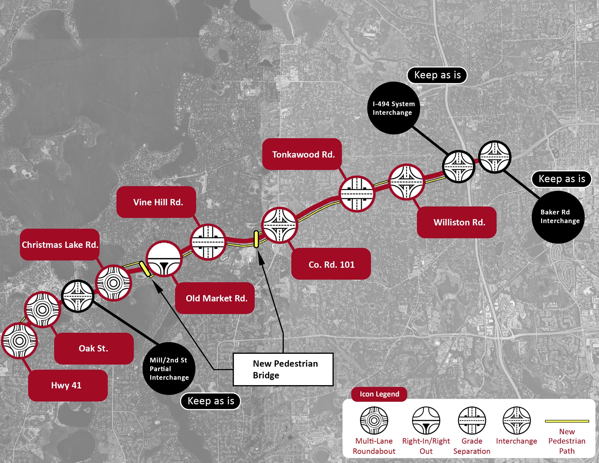 View full-size imageKey features
 - Multi-lane roundabouts at Hwy 41, Oak St., Christmas Lake Rd. and Old Market Rd.
- New interchanges at Co. Rd. 101 and Williston Rd.
- Grade separations at Vine Hill Rd. and Tonkawood Rd.
- Two pedestrian bridges (Old Market and Minnetonka High School)
- Improved multi-modal connections (sidewalks and trails)
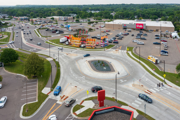 Example of a multi-lane roundabout.
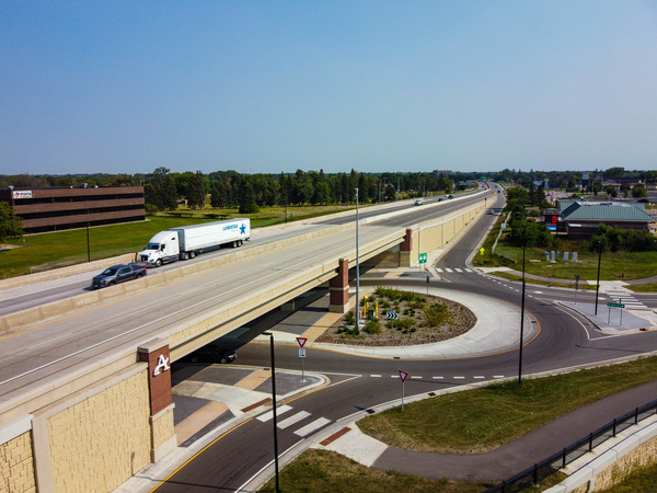 Example of grade separation and an interchange.Why was this selected?
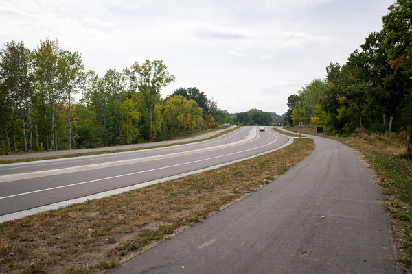 Example of a multi-use trail along the highway.
- The hybrid option was recommended as the preferred alternative because it addresses highway needs by enhancing vehicle mobility, improving traffic safety and offering safer pedestrian crossing opportunities.
- The hybrid option aligns proposed improvements with current traffic volumes by prioritizing grade-separated solutions in areas identified as having the greatest need.
- Full freeway conversion could be considered long-term if Hwy 7 traffic keeps increasing.
- Recommendations include new connections and improved crossing opportunities for bicycles and pedestrians.
Recommended improvements comment periodThe comment period for the recommended improvements closed on Nov. 30. Thank you to everyone who provided comments. Comments are being reviewed and will be used to guide future design updates in the study area. Sign up for email updates to receive updates on the study.
How we used public feedback
We gathered feedback from the public on the study design alternatives through community pop-ups, an online public meeting and an online survey. Your feedback was used to evaluate the design alternatives and help select the recommended improvement. Multiple communication methods were used to reach the public, including emails, social media and partner social media and communications and community pop-up events.
The survey was open to the public for four weeks from May 5, 2025, to June 4, 2025. In total, there were:
- 775 responses to the online survey
- 93 discussions held through community pop-ups
- 58 online public meeting attendees
- 29 comments submitted
Segment 1 feedback
55% either strongly agree or agree that the roundabout option was preferred, compared to 25% for other intersection improvements or 15% for leaving the road as-is.
Segment 2 feedback
60% either strongly agreed or agreed that the hybrid option was preferred, compared to 14% for leaving the road as is, 36% for at-grade improvements, 66% for grade-separated improvements
Next steps
Following the public comment period, comments on the recommended improvements will be reviewed and summarized. The study team will adjust the recommended improvements as needed, finalize documentation and prepare the final study report.
After the study is completed, the recommended improvements from the study will undergo a preliminary design and engineering process for refinement and environmental documentation. This process will include more opportunities for the public to give input on the design improvements for the upcoming project from Wildwood Ave. in St. Bonifacius to .2 miles east of Mill St. in the City of Shorewood.
Recommended improvements carried forward from the study that are not a part of the upcoming pavement project will be explored and refined as part of future projects. There will also be opportunities for public input on these recommended improvements as they move forward in the project development process. -
Public engagement update
Share Public engagement update on Facebook Share Public engagement update on Twitter Share Public engagement update on Linkedin Email Public engagement update linkWe gathered feedback from the public on the study design alternatives through pop-up’s and events, an online public meeting and an online survey. Thank you to everyone who participated in the survey and shared their feedback at events and meeting. There were 775 responses to the survey. The survey closed on Wed, June 4, 2025. If you missed the deadline and would still like to submit your feedback on the design alternatives, you can leave a comment or question or reach out to the Hwy 7 study team at hwy.7.study.info@state.mn.us or 651-234-7505.
The study team is currently analyzing the feedback received from the public and evaluating the design alternatives. We will share more information when the analysis and evaluation is completed.
If you haven’t already, sign up for email updates to stay up to date on this study.
-
Study design alternatives
Share Study design alternatives on Facebook Share Study design alternatives on Twitter Share Study design alternatives on Linkedin Email Study design alternatives linkWe have created several design alternatives for Hwy 7 using the current conditions of the road, study area needs and public feedback. The alternatives have been broken down by segments because the study area spans an 18-mile stretch of road with different needs.
Segment 1 (Hwy 7 from the Hennepin/Carver County line in St. Bonifacius to Hwy 41 in Shorewood)
Segment 2 (Hwy 7 from Hwy 41 in Shorewood to the Baker Rd. interchange in Minnetonka)
Alternatives have only been developed from the Hennepin/Carver County line in St. Bonifacius to Baker Rd. interchange in Minnetonka due to changes in traffic volume and the experiences of drivers and pedestrians, which were discovered during the existing conditions analysis. Future studies will consider evaluation of Hwy 7 east of Baker Rd.
Read on to learn more about what is being proposed and how each concept performed against the study needs.
Segment 1 overview
Segment 1 includes the west area of Hwy 7, spanning from the Hennepin/Carver County line in St. Bonifacius to Hwy 41 in Shorewood. The highway is primarily two lanes with one lane in each direction. The biggest challenges on this segment are head-on crashes and unsafe crossings at intersections.
There are three alternatives for Segment 1:
- Alternative 1 — No build or keep as is: Hwy 7 would remain as it is today with minor safety and/or capacity improvements.
- Alternative 2 — Roundabouts: Both single and multi-lane roundabouts are being considered to decrease crashes and improve travel times. Roundabouts show an 86 percent decrease in fatal crashes, an 83 percent decrease in life-altering injury crashes, and a 42 percent overall decrease in the injury crash rate at intersections. Learn more about roundabouts.
-
Alternative 3 — Improved intersections: A variety of improved intersections are being considered for this option. These sorts of intersections are proven to reduce serious and fatal crashes caused by “T bone” crashes at intersections:
- 3/4 intersection: This means that left turns from the side road onto the main road are not allowed.
- Reduced conflict intersection (RCI)/J-turns: Learn more about J-turns.
- Green T intersection: Used at t-intersections, this design helps reduce delays and improve efficiency by allowing continuous movement for one direction of traffic on the main road. Other specialty turn lanes will be added to allow cars to enter and exit Hwy 7 more safely.
All alternatives besides the no build/keep as alternative would include the addition of a concrete median between intersections to reduce head-on crashes that are significant in this segment.

Segment 1 performance
Each alternative was rated using the study area needs identified in the first phase of the study. A rating of one shows minimal improvement, while a rating of three shows the most improvement. (3 = most improvement, 1 = minimal improvement)
Segment 1 area needs
Alternative 1
(No build/keep as is)Alternative 2 (Roundabouts)
Alternative 3
(Intersection improvements)Vehicle safety
1
3
2
Vehicle mobility
2
2
2
Walkability/bikeability
1
2
2
Maintenance, cost, plan consistency
2
2
1
Social, economic, and environmental considerations
3
2
1
Segment 1 Alternative 1: No build/keep as is
- Two lane, undivided roadway between intersections
- Stop signs at Wildwood Ave., Highland Rd. and Minnewashta Pkwy.
- Signals at Co. Rd. 92, Co. Rd. 44, Co. Rd. 13, and Hwy 41
- Single lane roundabout at King’s Point Rd.
Benefits
- Cost savings
- Minimize environmental impacts
Challenges
Minimal safety and operational benefits
Segment 1 Alternative 2: Roundabouts
Key features- Median barrier between the intersections
- 3/4 intersection at Wildwood Ave. and Highland Rd.
- Single-lane roundabouts at Co. Rd. 92, Co. Rd. 44, Co. Rd. 13, and Minnewashta Pkwy.
- Multi-lane roundabouts at King’s Point Rd. and Hwy 41
Benefits
- Improved safety for intersection and main road related crashes
- Anticipated reduction in intersection delay
Challenges
Longer travel distances
Segment 1 Alternative 3: Improved intersections
- Median barrier along the roadway
- 3/4 intersections at Wildwood Ave. and Highland Rd.
- Signalized intersection at Co. Rd. 92
- Reduced conflict intersection (RCI)/J-turns at Co. Rd. 13, Minnewashta Pkwy. and Hwy 41
- Roundabout at King’s Point Rd.
- Green T at Co. Rd. 44
Benefits
- Improved main road travel time
- Improved safety for intersection and main road related crashes
Challenges
- Potential increase in off-peak side road delay
- Pedestrian crossing safety at non-signal locations
- Increased cost and impacts
- Longer travel distances
Segment 2 overview
Segment 2 spans Hwy 7 from Hwy 41 in Shorewood to the Baker Rd. interchange in Minnetonka. The road has two lanes in each direction that are separated by a median. The biggest issues in this area are vehicle and pedestrian safety and travel time reliability.
There are three alternatives for Segment 2:
Alternative 1 — No build or keep as is: Hwy 7 would remain as it is today with minor safety and/or capacity improvements.
- Alternative 2 — At-grade intersections: An at-grade intersection is any intersection that keeps all lanes of travel at grade. This can include signals, roundabouts, reduced conflict intersection (RCI)/J-turns or other at-grade improvements. The goal of at-grade intersections is to improve safety by reducing the number and severity of angle crashes.
- Alternative 3 — Grade-separated intersections: Grade-separated intersections use overpasses or underpasses to keep intersecting travel lanes apart. These types of intersections are ideal for roads with high traffic volumes and significant left-turn movements. These types of intersections enhance overall capacity and support uninterrupted traffic flow in both directions along the main road. Additionally, they provide safe routes for pedestrians by allowing them to cross above or below the traffic lanes.
- Alternative 4 — Both at-grade and grade-separated intersections: This alternative uses a mixture of both grade-separated and at-grade intersection solutions.
Each alternative, besides no build or keep as is, includes continuation of a concrete or grass median throughout the segment.

Segment 2 performance
Each alternative was rated using the study area needs identified in the first phase of the study. A rating of one shows minimal improvement, while a rating of three shows the most improvement. (3 = most improvement, 1 = minimal improvement)
Segment 2 area needs
Alternative 1
(No build or keep as is)Alternative 2 (At-grade intersections)
Alternative 3 (Grade-separated intersections)
Alternative 4
(Both at-grade and grade separated)Vehicle safety
1
1
3
3
Vehicle mobility
2
2
3
3
Walkability/bikeability
1
2
3
2
Maintenance, cost, plan consistency
2
2
1
2
Social, economic, and environmental considerations
3
2
2
2
Segment 2 Alternative 1: No build/keep as is
Key features
- Barrier and/or median separation between travel lanes
- Signal intersections at Hwy 41, Oak St., Christmas Lake Rd., Old Market Rd., Vine Hill Rd., Co. Rd. 101, Tonkawood Rd. and Williston Rd.
- Interchanges at Mill / 2nd St., I-494 and Baker Rd. (keep as is)
Benefits
- Cost savings
- Minimal environmental impact
Challenges
Minimal safety and operational benefits
Segment 2 Alternative 2: At-grade intersections
Key features
- Multi-lane roundabouts at Hwy 41, Oak St., Christmas Lake Rd., Old Market Rd. and Vine Hill Rd.
- Interchanges at Mill / 2nd St., I-494 and Baker Rd. (keep as is)
- Continuous flow intersection at Co. Rd. 101
- Revised signal at Tonkawood Rd. (update signal timing)
- Signalized reduced conflict intersection (RCI)/J-turn at Williston Rd.
Benefits
- Vehicle safety improvements
- Pedestrian safety improves at roundabouts and signalized reduced conflict intersection (RCI)/J-turn
- Lower cost than freeway with grade-separated crossings
Challenges
- Lower overall safety benefit than freeway
- Main road mobility challenge
- Pedestrian/bicycle crossings at-grade with vehicle
Segment 2 Alternative 3: Grade-separated intersections
Key features
- Interchanges at Hwy 41, Oak St., Mill / 2nd St. (keep as is), Vine Hill Rd., Co. Rd. 101, Williston Rd., I-494 (keep as is) and Baker Rd. (keep as is)
- Right-in / right-out at Christmas Lake Rd. and Old Market Rd.
- Grade separation at Tonkawood Rd .
Benefits
- Greatest safety and mobility improvements
- Remove main road crossing conflicts between pedestrian/bicycle and vehicle
Challenges
- Highest cost
- Highest impacts
- Difficult to implement
Segment 2 Alternative 4: Both at-grade and grade separated intersections
Key features
- Multi-lane roundabouts at Hwy 41, Oak St., Christmas Lake Rd. and Old Market Rd.
- Interchanges at Mill / 2nd St. (keep as is), Williston Rd., I-494 (keep as is), and Baker Rd. (keep as is)
- Grade separations at Vine Hill Rd. and Tonkawood Rd.
Benefits
- Optimized mobility and safety based on traffic volumes
- Improved bike and pedestrian safety
Challenges
High cost and impact for freeway segment
-
Engagement summary and study area needs
Share Engagement summary and study area needs on Facebook Share Engagement summary and study area needs on Twitter Share Engagement summary and study area needs on Linkedin Email Engagement summary and study area needs linkWe gathered feedback from the public on the current conditions along and across Hwy 7, including safety and mobility concerns with an online survey and comment map in June and July of 2024. Thank you to everyone who participated in the survey and comment map. Your feedback helped us understand your experiences of Hwy 7 and ideas for improvement. The survey and comment map closed on Sun, July 7, 2024. If you missed the deadline and would still like to submit your feedback, you can leave a comment or question or reach out to the Hwy 7 study team at hwy.7.study.info@state.mn.us or 651-234-7505.
What people saidAccording to the survey results, 60% of survey respondents use Hwy 7 daily, while 30% of respondents use Hwy 7 multiple times per week. Ninety (90) percent of all survey respondents are frequent users of Hwy 7.
According to the survey results, 52% of respondents reported that driving conditions do not feel safe or comfortable on the road, 75% of respondents said that walking conditions are not safe or comfortable and 71% of respondents said that biking conditions are not safe or comfortable along Hwy 7.
Looking to the future of Hwy 7, we asked participants to rate the importance of several elements. The results for those who marked these elements as “Important” and “Very important” are as follows:
- Safer intersections: 93%
- Reduced congestion: 87%
- Fewer driveway conflicts: 68%
- Better pedestrian facilities: 66%
- More environmentally friendly roadway: 57%
- Better access to businesses: 56%
- Better bike facilities: 48%
The top 10 themes mentioned in the survey were:
- Traffic
- Congestion
- Speed and traffic violations
- Infrastructure improvements
- Public transit
- Environmental preservation
- Community connectivity
- Safety
- Pedestrian and bicyclist safety
- Noise
Read the full engagement summary.
Study area needsAs a part of the Hwy 7 study, we also gathered and analyzed information about the study area. This included existing community plans, traffic counts, crash history, and road operations. Based on this analysis, we identified the following needs for the study area:
- Vehicle safety: Vehicle safety is an identified need along Hwy 7. This is documented in the history of fatal and severe injury crashes that have occurred. Multiple intersections exceed statewide averages for crashes and severity. The most severe crash types are lane departure crashes and angle crashes at intersections.
- Vehicle mobility: Vehicle mobility is an identified need along Hwy 7. There is a high level of side street delay at both signalized and unsignalized intersections. Mainline delay exists at multiple intersections along the road and is anticipated to increase in the future.
- Walkability / bikeabilty: Walkability and bikeability is a need along Hwy 7 due to the poor safety performance including fatalities as well as the difficulty crossing and traveling along the highway. Hwy 7 is also identified in several local and regional plans to improve mobility for multiple modes of transportation along the road.
Next stepsBased on the current conditions of the roadway, study area needs and the public feedback we received, we will develop ideas for improvements and get feedback from the public later in the study through public meetings, events and surveys.
Sign up for email updates to receive information on how you can share your input and stay up to date on this study.
-
Meetings and events
Share Meetings and events on Facebook Share Meetings and events on Twitter Share Meetings and events on Linkedin Email Meetings and events linkPublic meetings and events
Upcoming
Information on upcoming meetings will be posted as details become available. Sign up for email updates to receive information on upcoming meetings and opportunities to provide feedback on this study.
Past
-
Nov. 8, 2025: In-person outreach, Cub Foods, Minnetonka
- Nov. 8, 2025: In-person outreach, Cub Foods, Shorewood
- May 20, 2025:Virtual public meeting
We held a virtual public meeting on May 20 to engage community members interested in the Hwy 7 study. The meeting highlighted various improvement alternatives and invited public input on which options would meet the needs of the study area. It began with a presentation that included interactive poll questions, followed by breakout rooms where study staff addressed questions and gathered additional feedback.
Here are some key things we heard:
- Participants emphasized the need for improved safety measures throughout the study area.
- There was broad support for infrastructure improvements aimed at improving safety, reducing delays and enhancing traffic flow.
- Residents raised concerns about noise and pollution from accelerating vehicles, especially near residential areas.
- Participants advocated for grade-separated crossings for pedestrians, such as tunnels and bridges, more sidewalks and improved visibility.
- Community members expressed concern about restricted access due to medians and redesigned intersections.
- May 17, 2025: In-person outreach, Trista Days, Minnetrista
-
May 10, 2025: In-person outreach, Cub Foods, Shorewood
- May 10, 2025: In-person outreach, Cub Foods, Minnetonka
Public meeting accommodations
MnDOT invites and encourages participation by all people in their programs, services and activities. If you need an ASL, a foreign language interpreter, or documents in an alternative format (such as braille, large print or in a different language) at no cost, please email your request to Janet Miller at ADArequest.dot@state.mn.us or call 651-366-4720. Relay service: 711.
If you need any other reasonable accommodation to participate (such as seating modification or auxiliary aids), please email your request to Accessibility.DOT@state.mn.us or call 1-833-400-8432. Relay service: 711.
-
Nov. 8, 2025: In-person outreach, Cub Foods, Minnetonka
-
Accessibility
Share Accessibility on Facebook Share Accessibility on Twitter Share Accessibility on Linkedin Email Accessibility linkAmericans with Disabilities Act

Speakers and raised arrows on APS signals provide information about the intersection to pedestrians with hearing and visual impairment. All MnDOT projects - both new construction and rehabilitation projects - must include evaluation to ensure compliance with the Americans with Disabilities Act. Components can include, but are not limited to adding curb cuts, truncated domes and accessible pedestrian signals. Read about MnDOT's transition plan to comply with the ADA.
Specifics for this study
- Determine what accessibility improvements are needed for a 2029 resurfacing project
Sign up for email updates
More information
More information
- Recommended improvements
- Public engagement update
- Study design alternatives
- Engagement summary and study area needs
- Meetings and events
- Accessibility
Location
- Hwy 7 between Hopkins Crossroads in Hopkins and the western Hennepin County line in St. Bonifacius
Benefits
- Understand peoples’ travel needs
- Understand types of improvements that people need and want
- Build stronger relationships with community partners, residents and their elected representatives
Cost
- Study: $1 million
Schedule
-
March through September 2024
Hwy 7 study — Hopkins to St. Bonifacius has finished this stageAnalysis and input
-
September 2024 through June 2025
Hwy 7 study — Hopkins to St. Bonifacius has finished this stageDevelop and evaluate alternatives
-
July through December 2025
Hwy 7 study — Hopkins to St. Bonifacius is currently at this stageStudy document
-
2029
this is an upcoming stage for Hwy 7 study — Hopkins to St. BonifaciusConstruction
Related studies
Connect with us
Contacts
-
MnDOT

Phone 651-234-7505 Email hwy.7.study.info@state.mn.us


